You are here: Home > Network List > TA - USArray Transportable Network (new EarthScope stations) Stations List
> Station N54A Moraine State Park, Portersville, PA, USA > Earthquake Result Viewer
N54A Moraine State Park, Portersville, PA, USA - Earthquake Result Viewer
| Earthquake location: |
Iceland |
| Earthquake latitude/longitude: |
64.7/-17.5 |
| Earthquake time(UTC): |
2014/08/26 (238) 01:26:08 GMT |
| Earthquake Depth: |
5.0 km |
| Earthquake Magnitude: |
5.7 MWP |
| Earthquake Catalog/Contributor: |
NEIC PDE/NEIC COMCAT |
|
| Network: |
TA USArray Transportable Network (new EarthScope stations) |
| Station: |
N54A Moraine State Park, Portersville, PA, USA |
| Lat/Lon: |
40.96 N/79.99 W |
| Elevation: |
408 m |
|
| Distance: |
42.3 deg |
| Az: |
267.034 deg |
| Baz: |
34.567 deg |
| Ray Param: |
0.07328495 |
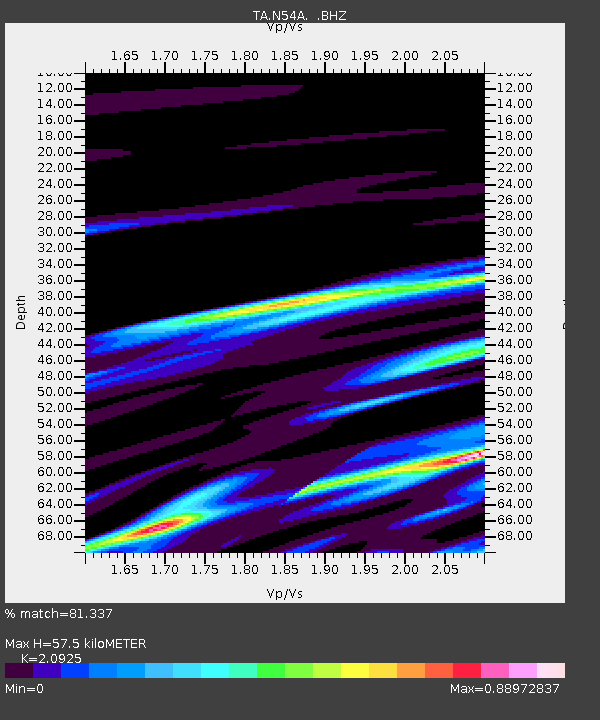
| Estimated Moho Depth: |
57.5 km |
| Estimated Crust Vp/Vs: |
2.09 |
| Assumed Crust Vp: |
6.121 km/s |
| Estimated Crust Vs: |
2.925 km/s |
| Estimated Crust Poisson's Ratio: |
0.35 |
|
| Radial Match: |
81.337 % |
| Radial Bump: |
400 |
| Transverse Match: |
52.7991 % |
| Transverse Bump: |
306 |
| SOD ConfigId: |
769524 |
| Insert Time: |
2014-09-09 02:18:30.855 +0000 |
| GWidth: |
2.5 |
| Max Bumps: |
400 |
| Tol: |
0.001 |
|

Signal To Noise
| Channel | StoN | STA | LTA |
| TA:N54A: :BHZ:20140826T01:33:31.77501Z | 2.169428 | 5.687401E-7 | 2.621613E-7 |
| TA:N54A: :BHN:20140826T01:33:31.77501Z | 1.1726916 | 2.4812604E-7 | 2.1158678E-7 |
| TA:N54A: :BHE:20140826T01:33:31.77501Z | 1.4001213 | 3.4451153E-7 | 2.4605833E-7 |
| Arrivals |
| Ps | 11 SECOND |
| PpPs | 28 SECOND |
| PsPs/PpSs | 38 SECOND |


