You are here: Home > Network List > IU - Global Seismograph Network (GSN - IRIS/USGS) Stations List
> Station RSSD Black Hills, South Dakota, USA > Earthquake Result Viewer
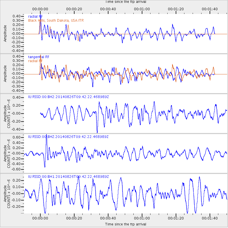
RSSD Black Hills, South Dakota, USA - Earthquake Result Viewer
*The percent match for this event was below the threshold and hence no stack was calculated.
| Earthquake location: |
Tonga Islands |
| Earthquake latitude/longitude: |
-15.2/-173.2 |
| Earthquake time(UTC): |
2014/08/26 (238) 09:30:12 GMT |
| Earthquake Depth: |
10 km |
| Earthquake Magnitude: |
5.6 MB |
| Earthquake Catalog/Contributor: |
NEIC PDE/NEIC COMCAT |
|
| Network: |
IU Global Seismograph Network (GSN - IRIS/USGS) |
| Station: |
RSSD Black Hills, South Dakota, USA |
| Lat/Lon: |
44.12 N/104.04 W |
| Elevation: |
2090 m |
|
| Distance: |
86.2 deg |
| Az: |
42.406 deg |
| Baz: |
244.675 deg |
| Ray Param: |
$rayparam |
*The percent match for this event was below the threshold and hence was not used in the summary stack. |
|
| Radial Match: |
49.378345 % |
| Radial Bump: |
400 |
| Transverse Match: |
65.00022 % |
| Transverse Bump: |
357 |
| SOD ConfigId: |
769524 |
| Insert Time: |
2014-09-09 09:52:19.349 +0000 |
| GWidth: |
2.5 |
| Max Bumps: |
400 |
| Tol: |
0.001 |
|
Signal To Noise
| Channel | StoN | STA | LTA |
| IU:RSSD:00:BHZ:20140826T09:42:22.468989Z | 2.5668736 | 2.6889228E-7 | 1.0475478E-7 |
| IU:RSSD:00:BH1:20140826T09:42:22.468989Z | 2.001092 | 1.5972986E-7 | 7.9821355E-8 |
| IU:RSSD:00:BH2:20140826T09:42:22.468989Z | 1.4128631 | 1.7227865E-7 | 1.2193583E-7 |
| Arrivals |
| Ps | |
| PpPs | |
| PsPs/PpSs | |


