You are here: Home > Network List > TA - USArray Transportable Network (new EarthScope stations) Stations List
> Station 435B Jarrell, TX, USA > Earthquake Result Viewer
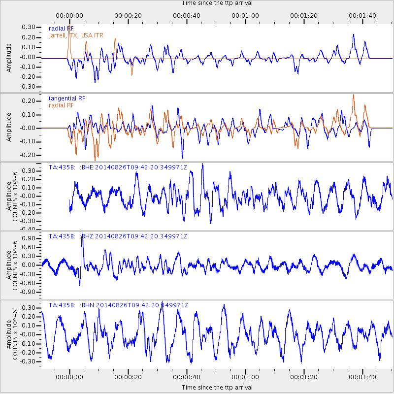
435B Jarrell, TX, USA - Earthquake Result Viewer
*The percent match for this event was below the threshold and hence no stack was calculated.
| Earthquake location: |
Tonga Islands |
| Earthquake latitude/longitude: |
-15.2/-173.2 |
| Earthquake time(UTC): |
2014/08/26 (238) 09:30:12 GMT |
| Earthquake Depth: |
10 km |
| Earthquake Magnitude: |
5.6 MB |
| Earthquake Catalog/Contributor: |
NEIC PDE/NEIC COMCAT |
|
| Network: |
TA USArray Transportable Network (new EarthScope stations) |
| Station: |
435B Jarrell, TX, USA |
| Lat/Lon: |
30.78 N/97.58 W |
| Elevation: |
248 m |
|
| Distance: |
85.7 deg |
| Az: |
56.694 deg |
| Baz: |
249.623 deg |
| Ray Param: |
$rayparam |
*The percent match for this event was below the threshold and hence was not used in the summary stack. |
|
| Radial Match: |
62.587337 % |
| Radial Bump: |
400 |
| Transverse Match: |
45.13738 % |
| Transverse Bump: |
400 |
| SOD ConfigId: |
769524 |
| Insert Time: |
2014-09-09 09:58:43.326 +0000 |
| GWidth: |
2.5 |
| Max Bumps: |
400 |
| Tol: |
0.001 |
|
Signal To Noise
| Channel | StoN | STA | LTA |
| TA:435B: :BHZ:20140826T09:42:20.349971Z | 2.8232262 | 3.87555E-7 | 1.372738E-7 |
| TA:435B: :BHN:20140826T09:42:20.349971Z | 0.6449261 | 9.027247E-8 | 1.3997337E-7 |
| TA:435B: :BHE:20140826T09:42:20.349971Z | 0.908246 | 9.093801E-8 | 1.00124865E-7 |
| Arrivals |
| Ps | |
| PpPs | |
| PsPs/PpSs | |


