You are here: Home > Network List > TA - USArray Transportable Network (new EarthScope stations) Stations List
> Station A04D Lummi Island, WA, USA > Earthquake Result Viewer
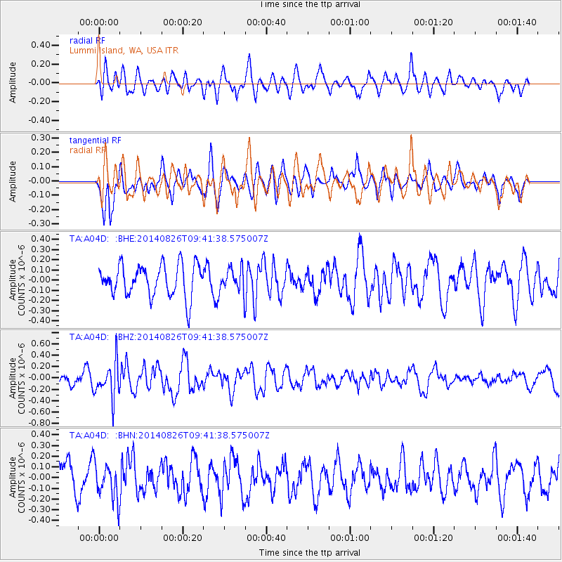
A04D Lummi Island, WA, USA - Earthquake Result Viewer
*The percent match for this event was below the threshold and hence no stack was calculated.
| Earthquake location: |
Tonga Islands |
| Earthquake latitude/longitude: |
-15.2/-173.2 |
| Earthquake time(UTC): |
2014/08/26 (238) 09:30:12 GMT |
| Earthquake Depth: |
10 km |
| Earthquake Magnitude: |
5.6 MB |
| Earthquake Catalog/Contributor: |
NEIC PDE/NEIC COMCAT |
|
| Network: |
TA USArray Transportable Network (new EarthScope stations) |
| Station: |
A04D Lummi Island, WA, USA |
| Lat/Lon: |
48.72 N/122.71 W |
| Elevation: |
13 m |
|
| Distance: |
77.8 deg |
| Az: |
31.493 deg |
| Baz: |
229.595 deg |
| Ray Param: |
$rayparam |
*The percent match for this event was below the threshold and hence was not used in the summary stack. |
|
| Radial Match: |
54.299694 % |
| Radial Bump: |
400 |
| Transverse Match: |
60.893623 % |
| Transverse Bump: |
400 |
| SOD ConfigId: |
769524 |
| Insert Time: |
2014-09-09 09:58:48.678 +0000 |
| GWidth: |
2.5 |
| Max Bumps: |
400 |
| Tol: |
0.001 |
|
Signal To Noise
| Channel | StoN | STA | LTA |
| TA:A04D: :BHZ:20140826T09:41:38.575007Z | 3.0064163 | 3.1111207E-7 | 1.03482705E-7 |
| TA:A04D: :BHN:20140826T09:41:38.575007Z | 1.0903344 | 1.616145E-7 | 1.482247E-7 |
| TA:A04D: :BHE:20140826T09:41:38.575007Z | 0.7533746 | 1.1657627E-7 | 1.5473879E-7 |
| Arrivals |
| Ps | |
| PpPs | |
| PsPs/PpSs | |


