You are here: Home > Network List > UW - Pacific Northwest Regional Seismic Network Stations List
> Station PASS Maple Falls, WA, USA > Earthquake Result Viewer
PASS Maple Falls, WA, USA - Earthquake Result Viewer
*The percent match for this event was below the threshold and hence no stack was calculated.
| Earthquake location: |
Santa Cruz Islands |
| Earthquake latitude/longitude: |
-12.0/166.4 |
| Earthquake time(UTC): |
2015/04/22 (112) 22:57:16 GMT |
| Earthquake Depth: |
74 km |
| Earthquake Magnitude: |
5.8 MB |
| Earthquake Catalog/Contributor: |
NEIC PDE/NEIC ALERT |
|
| Network: |
UW Pacific Northwest Regional Seismic Network |
| Station: |
PASS Maple Falls, WA, USA |
| Lat/Lon: |
49.00 N/122.09 W |
| Elevation: |
174 m |
|
| Distance: |
87.2 deg |
| Az: |
38.715 deg |
| Baz: |
248.303 deg |
| Ray Param: |
$rayparam |
*The percent match for this event was below the threshold and hence was not used in the summary stack. |
|
| Radial Match: |
54.724888 % |
| Radial Bump: |
400 |
| Transverse Match: |
64.01013 % |
| Transverse Bump: |
400 |
| SOD ConfigId: |
7422571 |
| Insert Time: |
2019-04-18 07:55:23.556 +0000 |
| GWidth: |
2.5 |
| Max Bumps: |
400 |
| Tol: |
0.001 |
|
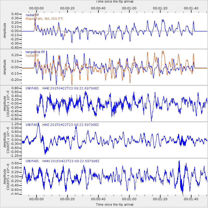
Signal To Noise
| Channel | StoN | STA | LTA |
| UW:PASS: :HHZ:20150422T23:09:22.697998Z | 4.4895897 | 6.105051E-7 | 1.3598239E-7 |
| UW:PASS: :HHN:20150422T23:09:22.697998Z | 1.122506 | 2.4085435E-7 | 2.1456843E-7 |
| UW:PASS: :HHE:20150422T23:09:22.697998Z | 1.2668613 | 3.2308031E-7 | 2.5502422E-7 |
| Arrivals |
| Ps | |
| PpPs | |
| PsPs/PpSs | |


