You are here: Home > Network List > US - United States National Seismic Network Stations List
> Station EGMT Eagleton, Montana, USA > Earthquake Result Viewer
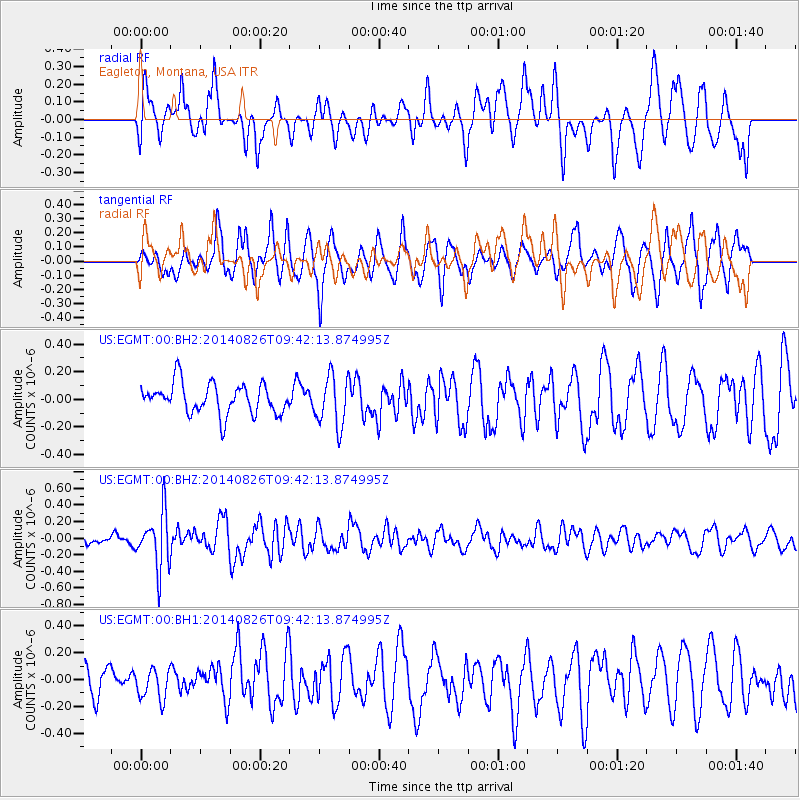
EGMT Eagleton, Montana, USA - Earthquake Result Viewer
*The percent match for this event was below the threshold and hence no stack was calculated.
| Earthquake location: |
Tonga Islands |
| Earthquake latitude/longitude: |
-15.2/-173.2 |
| Earthquake time(UTC): |
2014/08/26 (238) 09:30:12 GMT |
| Earthquake Depth: |
10 km |
| Earthquake Magnitude: |
5.6 MB |
| Earthquake Catalog/Contributor: |
NEIC PDE/NEIC COMCAT |
|
| Network: |
US United States National Seismic Network |
| Station: |
EGMT Eagleton, Montana, USA |
| Lat/Lon: |
48.02 N/109.75 W |
| Elevation: |
1055 m |
|
| Distance: |
84.5 deg |
| Az: |
37.088 deg |
| Baz: |
240.131 deg |
| Ray Param: |
$rayparam |
*The percent match for this event was below the threshold and hence was not used in the summary stack. |
|
| Radial Match: |
65.728134 % |
| Radial Bump: |
400 |
| Transverse Match: |
72.84321 % |
| Transverse Bump: |
400 |
| SOD ConfigId: |
769524 |
| Insert Time: |
2014-09-09 10:01:37.906 +0000 |
| GWidth: |
2.5 |
| Max Bumps: |
400 |
| Tol: |
0.001 |
|
Signal To Noise
| Channel | StoN | STA | LTA |
| US:EGMT:00:BHZ:20140826T09:42:13.874995Z | 3.2673542 | 3.3209471E-7 | 1.0164025E-7 |
| US:EGMT:00:BH1:20140826T09:42:13.874995Z | 0.79200286 | 1.14547E-7 | 1.4462952E-7 |
| US:EGMT:00:BH2:20140826T09:42:13.874995Z | 1.6764169 | 1.8248659E-7 | 1.0885514E-7 |
| Arrivals |
| Ps | |
| PpPs | |
| PsPs/PpSs | |


