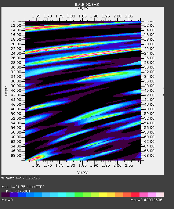
ALE Alert, N.W.T., Canada - Earthquake Result Viewer

Earthquake location: Southwestern Ryukyu Isl., Japan
Earthquake latitude/longitude: 23.5/123.5
Earthquake time(UTC): 2009/08/17 (229) 00:05:49 GMT
Earthquake Depth: 20 km
Earthquake Magnitude: 6.2 MB, 6.6 MS, 6.7 MW, 6.6 MW
Earthquake Catalog/Contributor: WHDF/NEIC
Network: II Global Seismograph Network (GSN - IRIS/IDA)
Station: ALE Alert, N.W.T., Canada
Lat/Lon: 82.50 N/62.35 W
Elevation: 60 m
Distance: 74.1 deg
Az: 0.797 deg
Baz: 354.419 deg
Ray Param: 0.052508593
Estimated Moho Depth: 21.75 km
Estimated Crust Vp/Vs: 1.74
Assumed Crust Vp: 6.287 km/s
Estimated Crust Vs: 3.619 km/s
Estimated Crust Poisson's Ratio: 0.25
Radial Match: 97.125725 %
Radial Bump: 400
Transverse Match: 87.15617 %
Transverse Bump: 400
SOD ConfigId: 2622
Insert Time: 2010-03-02 01:12:33.238 +0000
GWidth: 2.5
Max Bumps: 400
Tol: 0.001

Signal To Noise

ChannelStoNSTALTA
II:ALE:00:BHN:20090817T00:16:52.748994Z31.899862.3094692E-67.239748E-8
II:ALE:00:BHE:20090817T00:16:52.748994Z25.7518988.828496E-73.4282895E-8
II:ALE:00:BHZ:20090817T00:16:52.748994Z2.81293259.139637E-83.2491492E-8
Arrivals
Ps2.6 SECOND
PpPs9.2 SECOND
PsPs/PpSs12 SECOND