You are here: Home > Network List > II - Global Seismograph Network (GSN - IRIS/IDA) Stations List
> Station ALE Alert, N.W.T., Canada > Earthquake Result Viewer
ALE Alert, N.W.T., Canada - Earthquake Result Viewer
| Earthquake location: |
Michoacan, Mexico |
| Earthquake latitude/longitude: |
18.2/-102.8 |
| Earthquake time(UTC): |
1997/01/11 (011) 20:28:26 GMT |
| Earthquake Depth: |
33 km |
| Earthquake Magnitude: |
6.5 MB, 6.9 MS, 7.1 UNKNOWN, 7.0 ME |
| Earthquake Catalog/Contributor: |
WHDF/NEIC |
|
| Network: |
II Global Seismograph Network (GSN - IRIS/IDA) |
| Station: |
ALE Alert, N.W.T., Canada |
| Lat/Lon: |
82.50 N/62.35 W |
| Elevation: |
60 m |
|
| Distance: |
66.2 deg |
| Az: |
5.338 deg |
| Baz: |
222.317 deg |
| Ray Param: |
0.057702556 |
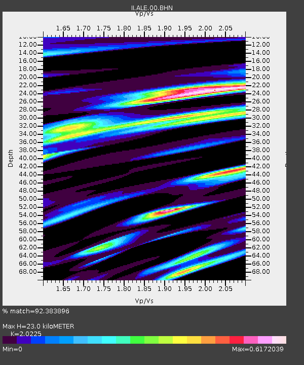
| Estimated Moho Depth: |
23.0 km |
| Estimated Crust Vp/Vs: |
2.02 |
| Assumed Crust Vp: |
6.287 km/s |
| Estimated Crust Vs: |
3.109 km/s |
| Estimated Crust Poisson's Ratio: |
0.34 |
|
| Radial Match: |
92.383896 % |
| Radial Bump: |
400 |
| Transverse Match: |
86.80608 % |
| Transverse Bump: |
400 |
| SOD ConfigId: |
4480 |
| Insert Time: |
2010-03-02 01:13:01.434 +0000 |
| GWidth: |
2.5 |
| Max Bumps: |
400 |
| Tol: |
0.001 |
|

Signal To Noise
| Channel | StoN | STA | LTA |
| II:ALE:00:BHN:19970111T20:38:39.807007Z | 5.3691883 | 2.6633284E-6 | 4.9603926E-7 |
| II:ALE:00:BHE:19970111T20:38:39.807007Z | 3.6411345 | 9.246266E-7 | 2.5393913E-7 |
| II:ALE:00:BHZ:19970111T20:38:39.807007Z | 3.094063 | 8.2599115E-7 | 2.6696003E-7 |
| Arrivals |
| Ps | 3.9 SECOND |
| PpPs | 11 SECOND |
| PsPs/PpSs | 15 SECOND |


