You are here: Home > Network List > TA - USArray Transportable Network (new EarthScope stations) Stations List
> Station D46A Sault St. Marie, ON, CAN > Earthquake Result Viewer
D46A Sault St. Marie, ON, CAN - Earthquake Result Viewer
| Earthquake location: |
Iceland |
| Earthquake latitude/longitude: |
64.7/-17.0 |
| Earthquake time(UTC): |
2014/08/27 (239) 02:50:39 GMT |
| Earthquake Depth: |
5.0 km |
| Earthquake Magnitude: |
5.6 M |
| Earthquake Catalog/Contributor: |
NEIC PDE/NEIC ALERT |
|
| Network: |
TA USArray Transportable Network (new EarthScope stations) |
| Station: |
D46A Sault St. Marie, ON, CAN |
| Lat/Lon: |
46.89 N/84.04 W |
| Elevation: |
353 m |
|
| Distance: |
39.4 deg |
| Az: |
276.409 deg |
| Baz: |
38.543 deg |
| Ray Param: |
0.07499773 |
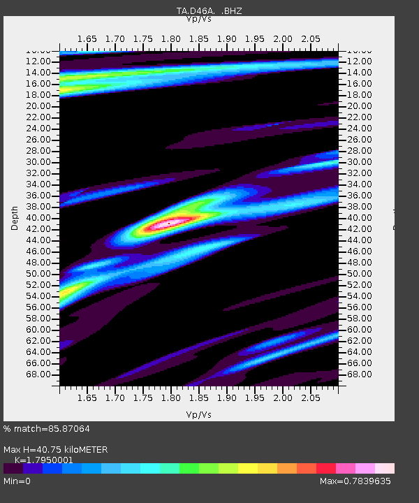
| Estimated Moho Depth: |
40.75 km |
| Estimated Crust Vp/Vs: |
1.80 |
| Assumed Crust Vp: |
6.467 km/s |
| Estimated Crust Vs: |
3.603 km/s |
| Estimated Crust Poisson's Ratio: |
0.27 |
|
| Radial Match: |
85.87064 % |
| Radial Bump: |
367 |
| Transverse Match: |
58.19998 % |
| Transverse Bump: |
400 |
| SOD ConfigId: |
769524 |
| Insert Time: |
2014-09-10 03:21:20.182 +0000 |
| GWidth: |
2.5 |
| Max Bumps: |
400 |
| Tol: |
0.001 |
|
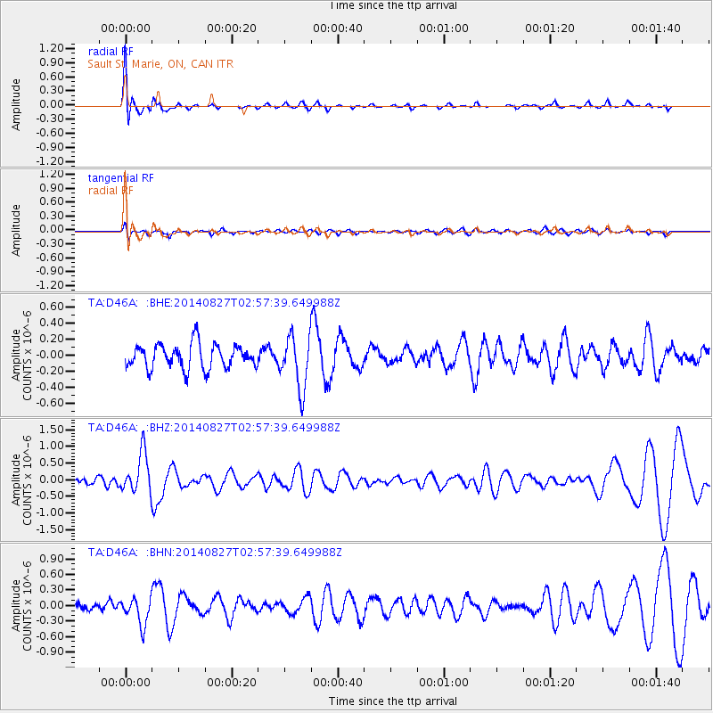
Signal To Noise
| Channel | StoN | STA | LTA |
| TA:D46A: :BHZ:20140827T02:57:39.649988Z | 3.4114757 | 6.0844997E-7 | 1.783539E-7 |
| TA:D46A: :BHN:20140827T02:57:39.649988Z | 3.37574 | 2.6097672E-7 | 7.730948E-8 |
| TA:D46A: :BHE:20140827T02:57:39.649988Z | 2.1893842 | 3.3198506E-7 | 1.5163398E-7 |
| Arrivals |
| Ps | 5.4 SECOND |
| PpPs | 16 SECOND |
| PsPs/PpSs | 22 SECOND |


