You are here: Home > Network List > TA - USArray Transportable Network (new EarthScope stations) Stations List
> Station MDND Maddock, ND, USA > Earthquake Result Viewer
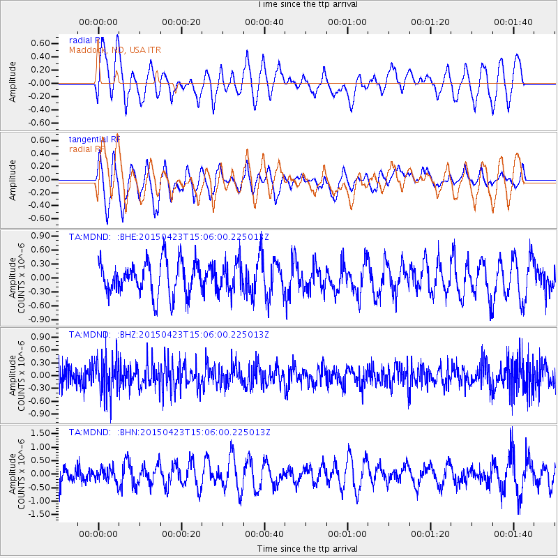
MDND Maddock, ND, USA - Earthquake Result Viewer
*The percent match for this event was below the threshold and hence no stack was calculated.
| Earthquake location: |
Rat Islands, Aleutian Islands |
| Earthquake latitude/longitude: |
51.7/176.3 |
| Earthquake time(UTC): |
2015/04/23 (113) 14:57:29 GMT |
| Earthquake Depth: |
42 km |
| Earthquake Magnitude: |
5.2 MW, 5.4 mb, 4.5 MS |
| Earthquake Catalog/Contributor: |
ISC/ISC |
|
| Network: |
TA USArray Transportable Network (new EarthScope stations) |
| Station: |
MDND Maddock, ND, USA |
| Lat/Lon: |
47.85 N/99.60 W |
| Elevation: |
479 m |
|
| Distance: |
51.5 deg |
| Az: |
58.838 deg |
| Baz: |
307.836 deg |
| Ray Param: |
$rayparam |
*The percent match for this event was below the threshold and hence was not used in the summary stack. |
|
| Radial Match: |
55.49173 % |
| Radial Bump: |
400 |
| Transverse Match: |
60.82324 % |
| Transverse Bump: |
400 |
| SOD ConfigId: |
7422571 |
| Insert Time: |
2019-04-18 08:04:07.584 +0000 |
| GWidth: |
2.5 |
| Max Bumps: |
400 |
| Tol: |
0.001 |
|
Signal To Noise
| Channel | StoN | STA | LTA |
| TA:MDND: :BHZ:20150423T15:06:00.225013Z | 2.2126136 | 4.5261365E-7 | 2.0456064E-7 |
| TA:MDND: :BHN:20150423T15:06:00.225013Z | 0.76286453 | 2.6848807E-7 | 3.5194722E-7 |
| TA:MDND: :BHE:20150423T15:06:00.225013Z | 0.8926483 | 3.2327236E-7 | 3.6214976E-7 |
| Arrivals |
| Ps | |
| PpPs | |
| PsPs/PpSs | |


