You are here: Home > Network List > TA - USArray Transportable Network (new EarthScope stations) Stations List
> Station L44A Lake County Forest Preserve, Grayslake, IL, USA > Earthquake Result Viewer
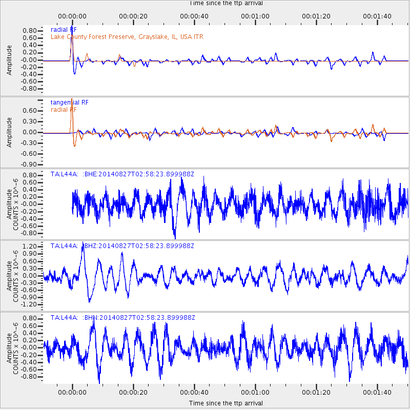
L44A Lake County Forest Preserve, Grayslake, IL, USA - Earthquake Result Viewer
*The percent match for this event was below the threshold and hence no stack was calculated.
| Earthquake location: |
Iceland |
| Earthquake latitude/longitude: |
64.7/-17.0 |
| Earthquake time(UTC): |
2014/08/27 (239) 02:50:39 GMT |
| Earthquake Depth: |
5.0 km |
| Earthquake Magnitude: |
5.6 M |
| Earthquake Catalog/Contributor: |
NEIC PDE/NEIC ALERT |
|
| Network: |
TA USArray Transportable Network (new EarthScope stations) |
| Station: |
L44A Lake County Forest Preserve, Grayslake, IL, USA |
| Lat/Lon: |
42.18 N/87.91 W |
| Elevation: |
202 m |
|
| Distance: |
44.9 deg |
| Az: |
275.506 deg |
| Baz: |
35.161 deg |
| Ray Param: |
$rayparam |
*The percent match for this event was below the threshold and hence was not used in the summary stack. |
|
| Radial Match: |
71.27985 % |
| Radial Bump: |
400 |
| Transverse Match: |
45.648216 % |
| Transverse Bump: |
362 |
| SOD ConfigId: |
769524 |
| Insert Time: |
2014-09-10 03:26:07.282 +0000 |
| GWidth: |
2.5 |
| Max Bumps: |
400 |
| Tol: |
0.001 |
|
Signal To Noise
| Channel | StoN | STA | LTA |
| TA:L44A: :BHZ:20140827T02:58:23.899988Z | 3.0424862 | 5.5596485E-7 | 1.8273373E-7 |
| TA:L44A: :BHN:20140827T02:58:23.899988Z | 1.7781378 | 2.5903987E-7 | 1.4568042E-7 |
| TA:L44A: :BHE:20140827T02:58:23.899988Z | 1.8067371 | 3.9730926E-7 | 2.1990431E-7 |
| Arrivals |
| Ps | |
| PpPs | |
| PsPs/PpSs | |


