You are here: Home > Network List > US - United States National Seismic Network Stations List
> Station MIAR Mount Ida, Arkansas, USA > Earthquake Result Viewer
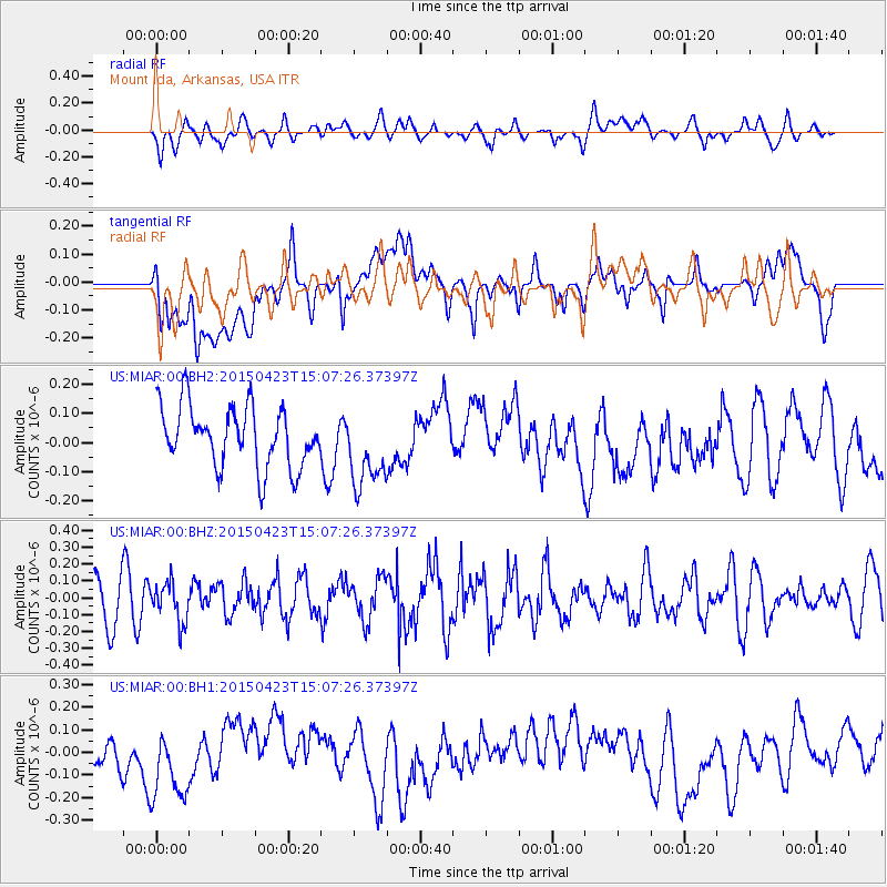
MIAR Mount Ida, Arkansas, USA - Earthquake Result Viewer
*The percent match for this event was below the threshold and hence no stack was calculated.
| Earthquake location: |
Rat Islands, Aleutian Islands |
| Earthquake latitude/longitude: |
51.7/176.3 |
| Earthquake time(UTC): |
2015/04/23 (113) 14:57:29 GMT |
| Earthquake Depth: |
42 km |
| Earthquake Magnitude: |
5.2 MW, 5.4 mb, 4.5 MS |
| Earthquake Catalog/Contributor: |
ISC/ISC |
|
| Network: |
US United States National Seismic Network |
| Station: |
MIAR Mount Ida, Arkansas, USA |
| Lat/Lon: |
34.55 N/93.58 W |
| Elevation: |
207 m |
|
| Distance: |
63.8 deg |
| Az: |
66.892 deg |
| Baz: |
316.156 deg |
| Ray Param: |
$rayparam |
*The percent match for this event was below the threshold and hence was not used in the summary stack. |
|
| Radial Match: |
43.22316 % |
| Radial Bump: |
400 |
| Transverse Match: |
30.603317 % |
| Transverse Bump: |
400 |
| SOD ConfigId: |
7422571 |
| Insert Time: |
2019-04-18 08:04:57.288 +0000 |
| GWidth: |
2.5 |
| Max Bumps: |
400 |
| Tol: |
0.001 |
|
Signal To Noise
| Channel | StoN | STA | LTA |
| US:MIAR:00:BHZ:20150423T15:07:26.37397Z | 0.6719981 | 1.1714449E-7 | 1.7432265E-7 |
| US:MIAR:00:BH1:20150423T15:07:26.37397Z | 1.9257635 | 1.8947422E-7 | 9.8389144E-8 |
| US:MIAR:00:BH2:20150423T15:07:26.37397Z | 1.2883922 | 1.3289171E-7 | 1.0314539E-7 |
| Arrivals |
| Ps | |
| PpPs | |
| PsPs/PpSs | |


