You are here: Home > Network List > TA - USArray Transportable Network (new EarthScope stations) Stations List
> Station O03E Paynes Creek, CA, USA > Earthquake Result Viewer
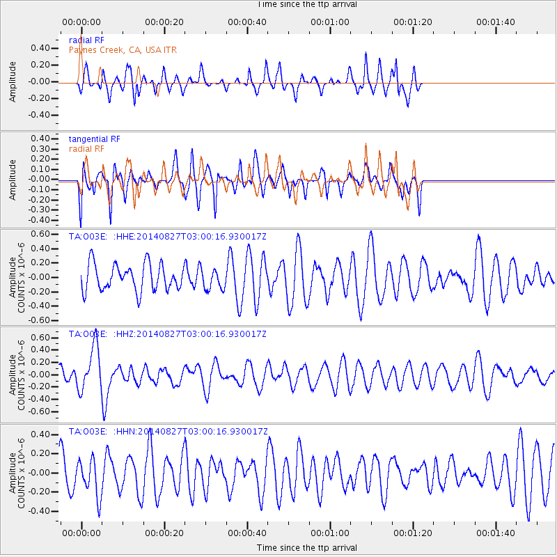
O03E Paynes Creek, CA, USA - Earthquake Result Viewer
*The percent match for this event was below the threshold and hence no stack was calculated.
| Earthquake location: |
Iceland |
| Earthquake latitude/longitude: |
64.7/-17.0 |
| Earthquake time(UTC): |
2014/08/27 (239) 02:50:39 GMT |
| Earthquake Depth: |
5.0 km |
| Earthquake Magnitude: |
5.6 M |
| Earthquake Catalog/Contributor: |
NEIC PDE/NEIC ALERT |
|
| Network: |
TA USArray Transportable Network (new EarthScope stations) |
| Station: |
O03E Paynes Creek, CA, USA |
| Lat/Lon: |
40.29 N/121.80 W |
| Elevation: |
967 m |
|
| Distance: |
60.1 deg |
| Az: |
301.479 deg |
| Baz: |
28.652 deg |
| Ray Param: |
$rayparam |
*The percent match for this event was below the threshold and hence was not used in the summary stack. |
|
| Radial Match: |
54.271336 % |
| Radial Bump: |
361 |
| Transverse Match: |
61.306675 % |
| Transverse Bump: |
363 |
| SOD ConfigId: |
769524 |
| Insert Time: |
2014-09-10 03:27:43.489 +0000 |
| GWidth: |
2.5 |
| Max Bumps: |
400 |
| Tol: |
0.001 |
|
Signal To Noise
| Channel | StoN | STA | LTA |
| TA:O03E: :HHZ:20140827T03:00:16.930017Z | 2.041497 | 3.7055412E-7 | 1.8151098E-7 |
| TA:O03E: :HHN:20140827T03:00:16.930017Z | 0.85236335 | 1.9940569E-7 | 2.3394446E-7 |
| TA:O03E: :HHE:20140827T03:00:16.930017Z | 0.7568004 | 1.3878983E-7 | 1.8339026E-7 |
| Arrivals |
| Ps | |
| PpPs | |
| PsPs/PpSs | |


