You are here: Home > Network List > TA - USArray Transportable Network (new EarthScope stations) Stations List
> Station P57A Homestead Farm, Martinsburg, WV, USA > Earthquake Result Viewer
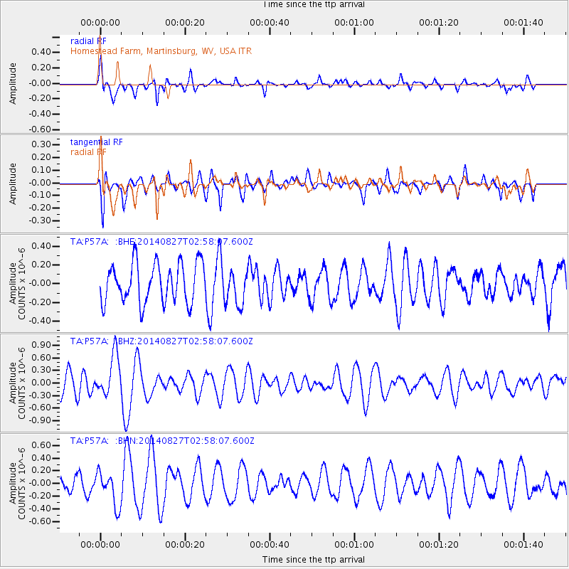
P57A Homestead Farm, Martinsburg, WV, USA - Earthquake Result Viewer
*The percent match for this event was below the threshold and hence no stack was calculated.
| Earthquake location: |
Iceland |
| Earthquake latitude/longitude: |
64.7/-17.0 |
| Earthquake time(UTC): |
2014/08/27 (239) 02:50:39 GMT |
| Earthquake Depth: |
5.0 km |
| Earthquake Magnitude: |
5.6 M |
| Earthquake Catalog/Contributor: |
NEIC PDE/NEIC ALERT |
|
| Network: |
TA USArray Transportable Network (new EarthScope stations) |
| Station: |
P57A Homestead Farm, Martinsburg, WV, USA |
| Lat/Lon: |
39.48 N/78.01 W |
| Elevation: |
191 m |
|
| Distance: |
42.8 deg |
| Az: |
264.365 deg |
| Baz: |
33.572 deg |
| Ray Param: |
$rayparam |
*The percent match for this event was below the threshold and hence was not used in the summary stack. |
|
| Radial Match: |
73.099266 % |
| Radial Bump: |
400 |
| Transverse Match: |
64.32191 % |
| Transverse Bump: |
400 |
| SOD ConfigId: |
769524 |
| Insert Time: |
2014-09-10 03:28:21.547 +0000 |
| GWidth: |
2.5 |
| Max Bumps: |
400 |
| Tol: |
0.001 |
|
Signal To Noise
| Channel | StoN | STA | LTA |
| TA:P57A: :BHZ:20140827T02:58:07.600Z | 2.1194932 | 5.117993E-7 | 2.414725E-7 |
| TA:P57A: :BHN:20140827T02:58:07.600Z | 3.2732587 | 2.7791808E-7 | 8.490563E-8 |
| TA:P57A: :BHE:20140827T02:58:07.600Z | 0.875619 | 1.8307577E-7 | 2.0908155E-7 |
| Arrivals |
| Ps | |
| PpPs | |
| PsPs/PpSs | |


