You are here: Home > Network List > TA - USArray Transportable Network (new EarthScope stations) Stations List
> Station R11A Troy Canyon, Currant, NV, USA > Earthquake Result Viewer
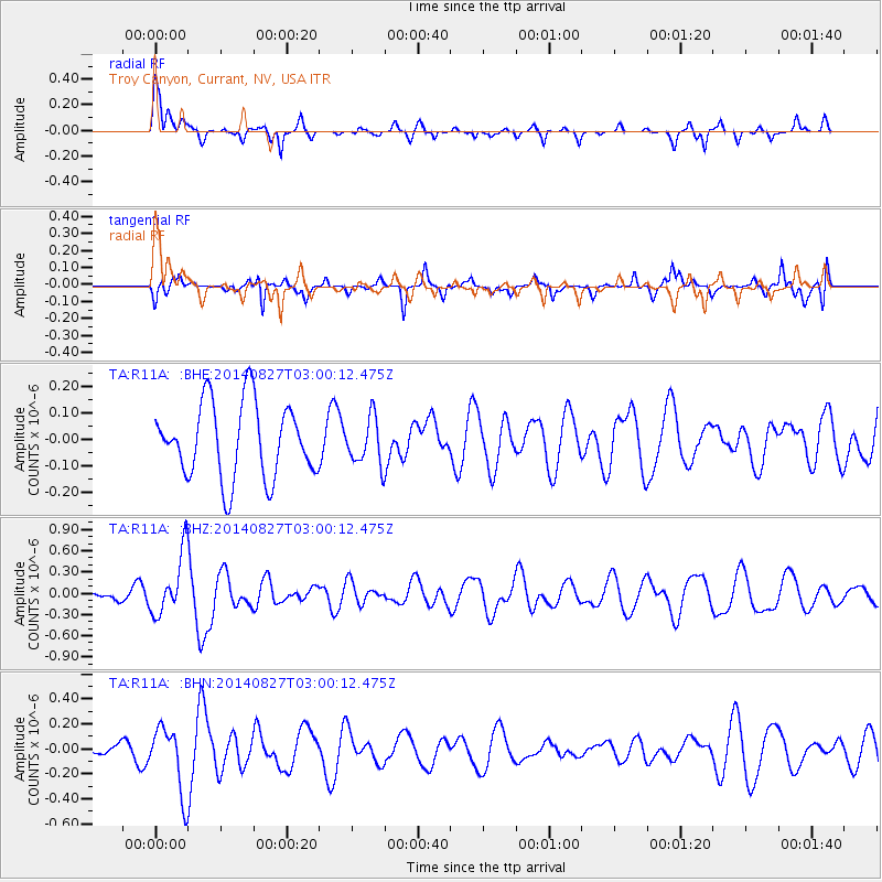
R11A Troy Canyon, Currant, NV, USA - Earthquake Result Viewer
*The percent match for this event was below the threshold and hence no stack was calculated.
| Earthquake location: |
Iceland |
| Earthquake latitude/longitude: |
64.7/-17.0 |
| Earthquake time(UTC): |
2014/08/27 (239) 02:50:39 GMT |
| Earthquake Depth: |
5.0 km |
| Earthquake Magnitude: |
5.6 M |
| Earthquake Catalog/Contributor: |
NEIC PDE/NEIC ALERT |
|
| Network: |
TA USArray Transportable Network (new EarthScope stations) |
| Station: |
R11A Troy Canyon, Currant, NV, USA |
| Lat/Lon: |
38.35 N/115.59 W |
| Elevation: |
1756 m |
|
| Distance: |
59.5 deg |
| Az: |
295.513 deg |
| Baz: |
29.577 deg |
| Ray Param: |
$rayparam |
*The percent match for this event was below the threshold and hence was not used in the summary stack. |
|
| Radial Match: |
66.42264 % |
| Radial Bump: |
317 |
| Transverse Match: |
62.15869 % |
| Transverse Bump: |
394 |
| SOD ConfigId: |
769524 |
| Insert Time: |
2014-09-10 03:28:51.044 +0000 |
| GWidth: |
2.5 |
| Max Bumps: |
400 |
| Tol: |
0.001 |
|
Signal To Noise
| Channel | StoN | STA | LTA |
| TA:R11A: :BHZ:20140827T03:00:12.475Z | 3.2453694 | 4.4240772E-7 | 1.3631967E-7 |
| TA:R11A: :BHN:20140827T03:00:12.475Z | 2.1586368 | 2.6382506E-7 | 1.2221837E-7 |
| TA:R11A: :BHE:20140827T03:00:12.475Z | 0.62622553 | 8.859075E-8 | 1.4146781E-7 |
| Arrivals |
| Ps | |
| PpPs | |
| PsPs/PpSs | |


