You are here: Home > Network List > TA - USArray Transportable Network (new EarthScope stations) Stations List
> Station Z41A Richland Creek Farm, El Dorado, AR, USA > Earthquake Result Viewer
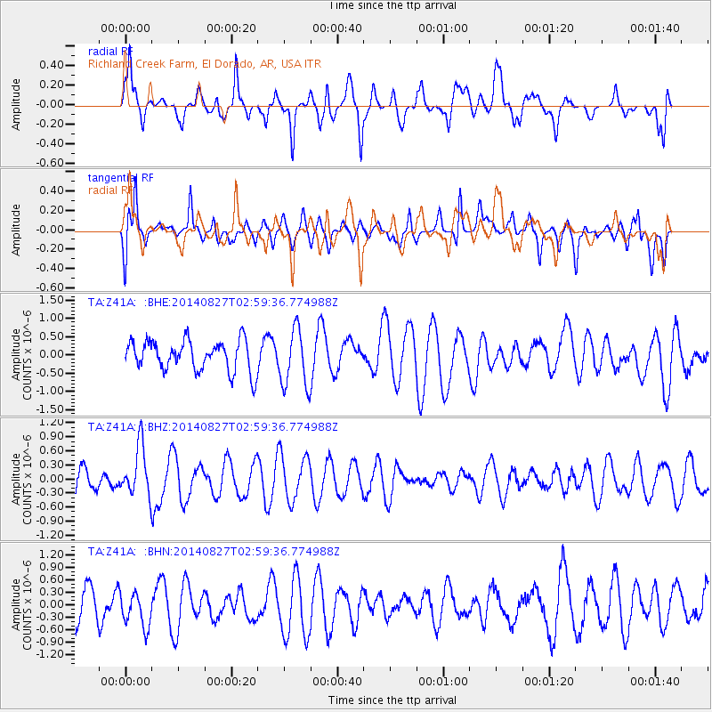
Z41A Richland Creek Farm, El Dorado, AR, USA - Earthquake Result Viewer
*The percent match for this event was below the threshold and hence no stack was calculated.
| Earthquake location: |
Iceland |
| Earthquake latitude/longitude: |
64.7/-17.0 |
| Earthquake time(UTC): |
2014/08/27 (239) 02:50:39 GMT |
| Earthquake Depth: |
5.0 km |
| Earthquake Magnitude: |
5.6 M |
| Earthquake Catalog/Contributor: |
NEIC PDE/NEIC ALERT |
|
| Network: |
TA USArray Transportable Network (new EarthScope stations) |
| Station: |
Z41A Richland Creek Farm, El Dorado, AR, USA |
| Lat/Lon: |
33.26 N/92.80 W |
| Elevation: |
62 m |
|
| Distance: |
54.4 deg |
| Az: |
273.423 deg |
| Baz: |
30.818 deg |
| Ray Param: |
$rayparam |
*The percent match for this event was below the threshold and hence was not used in the summary stack. |
|
| Radial Match: |
67.47555 % |
| Radial Bump: |
400 |
| Transverse Match: |
66.02274 % |
| Transverse Bump: |
400 |
| SOD ConfigId: |
769524 |
| Insert Time: |
2014-09-10 03:30:45.878 +0000 |
| GWidth: |
2.5 |
| Max Bumps: |
400 |
| Tol: |
0.001 |
|
Signal To Noise
| Channel | StoN | STA | LTA |
| TA:Z41A: :BHZ:20140827T02:59:36.774988Z | 2.2468762 | 5.4174717E-7 | 2.4111125E-7 |
| TA:Z41A: :BHN:20140827T02:59:36.774988Z | 0.86444193 | 4.1064214E-7 | 4.7503727E-7 |
| TA:Z41A: :BHE:20140827T02:59:36.774988Z | 1.9295487 | 8.0157054E-7 | 4.154186E-7 |
| Arrivals |
| Ps | |
| PpPs | |
| PsPs/PpSs | |


