You are here: Home > Network List > TA - USArray Transportable Network (new EarthScope stations) Stations List
> Station A21K Barrow, AK, USA > Earthquake Result Viewer
A21K Barrow, AK, USA - Earthquake Result Viewer
| Earthquake location: |
Iceland |
| Earthquake latitude/longitude: |
64.7/-17.0 |
| Earthquake time(UTC): |
2014/08/27 (239) 02:50:39 GMT |
| Earthquake Depth: |
5.0 km |
| Earthquake Magnitude: |
5.6 M |
| Earthquake Catalog/Contributor: |
NEIC PDE/NEIC ALERT |
|
| Network: |
TA USArray Transportable Network (new EarthScope stations) |
| Station: |
A21K Barrow, AK, USA |
| Lat/Lon: |
71.32 N/156.62 W |
| Elevation: |
577 m |
|
| Distance: |
41.5 deg |
| Az: |
341.611 deg |
| Baz: |
24.902 deg |
| Ray Param: |
0.073780306 |
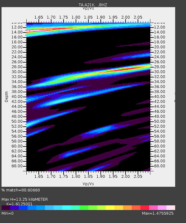
| Estimated Moho Depth: |
13.25 km |
| Estimated Crust Vp/Vs: |
1.61 |
| Assumed Crust Vp: |
6.048 km/s |
| Estimated Crust Vs: |
3.751 km/s |
| Estimated Crust Poisson's Ratio: |
0.19 |
|
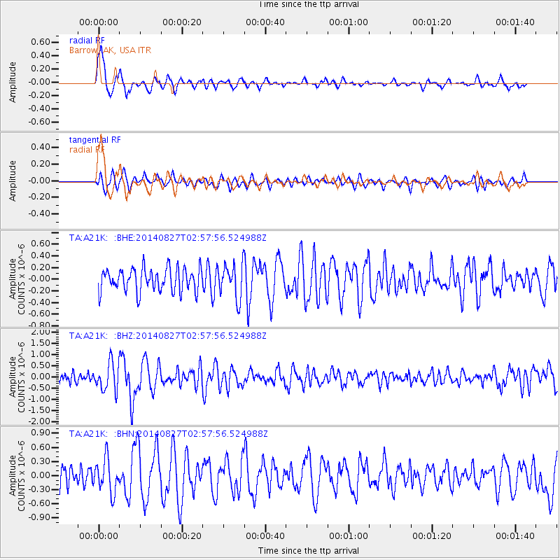
| Radial Match: |
88.60668 % |
| Radial Bump: |
366 |
| Transverse Match: |
66.32689 % |
| Transverse Bump: |
400 |
| SOD ConfigId: |
769524 |
| Insert Time: |
2014-09-10 03:30:53.440 +0000 |
| GWidth: |
2.5 |
| Max Bumps: |
400 |
| Tol: |
0.001 |
|
Signal To Noise
| Channel | StoN | STA | LTA |
| TA:A21K: :BHZ:20140827T02:57:56.524988Z | 3.3636634 | 6.334505E-7 | 1.8832161E-7 |
| TA:A21K: :BHN:20140827T02:57:56.524988Z | 2.1194494 | 3.6604536E-7 | 1.7270776E-7 |
| TA:A21K: :BHE:20140827T02:57:56.524988Z | 1.5319614 | 3.024903E-7 | 1.9745295E-7 |
| Arrivals |
| Ps | 1.4 SECOND |
| PpPs | 5.4 SECOND |
| PsPs/PpSs | 6.8 SECOND |


