You are here: Home > Network List > YE11 - Testing TA and FA Vaults and Directly Buried Sensors (3T) Stations List
> Station PIC2 Poker Flats, Alaska, USA > Earthquake Result Viewer
PIC2 Poker Flats, Alaska, USA - Earthquake Result Viewer
| Earthquake location: |
Iceland |
| Earthquake latitude/longitude: |
64.7/-17.0 |
| Earthquake time(UTC): |
2014/08/27 (239) 02:50:39 GMT |
| Earthquake Depth: |
5.0 km |
| Earthquake Magnitude: |
5.6 M |
| Earthquake Catalog/Contributor: |
NEIC PDE/NEIC ALERT |
|
| Network: |
YE Testing TA and FA Vaults and Directly Buried Sensors (3T) |
| Station: |
PIC2 Poker Flats, Alaska, USA |
| Lat/Lon: |
65.12 N/147.43 W |
| Elevation: |
502 m |
|
| Distance: |
45.6 deg |
| Az: |
333.169 deg |
| Baz: |
27.308 deg |
| Ray Param: |
0.07121005 |
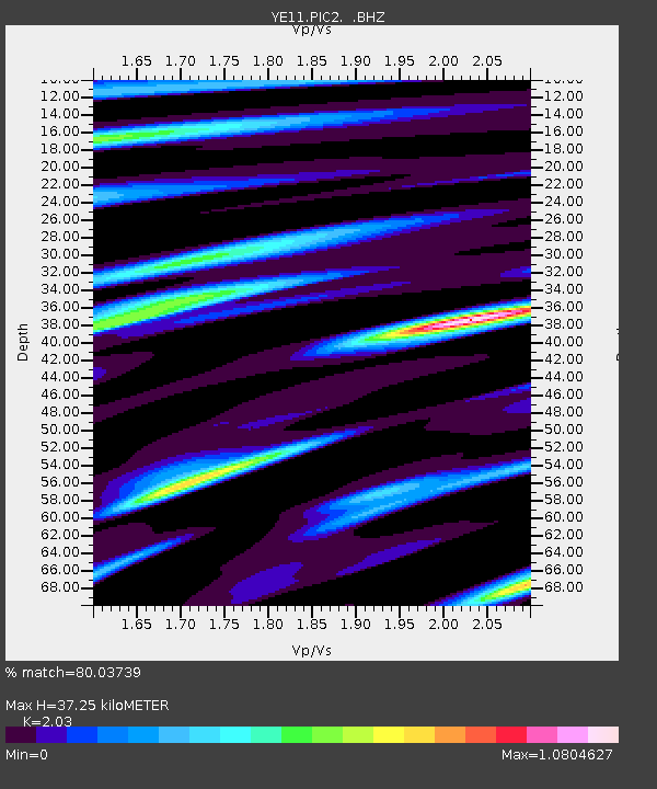
| Estimated Moho Depth: |
37.25 km |
| Estimated Crust Vp/Vs: |
2.03 |
| Assumed Crust Vp: |
6.566 km/s |
| Estimated Crust Vs: |
3.235 km/s |
| Estimated Crust Poisson's Ratio: |
0.34 |
|
| Radial Match: |
80.03739 % |
| Radial Bump: |
400 |
| Transverse Match: |
61.87951 % |
| Transverse Bump: |
400 |
| SOD ConfigId: |
769524 |
| Insert Time: |
2014-09-10 03:37:14.301 +0000 |
| GWidth: |
2.5 |
| Max Bumps: |
400 |
| Tol: |
0.001 |
|

Signal To Noise
| Channel | StoN | STA | LTA |
| YE:PIC2: :BHZ:20140827T02:58:29.399988Z | 3.90902 | 2.2771293E-7 | 5.8253203E-8 |
| YE:PIC2: :BHN:20140827T02:58:29.399988Z | 2.2559693 | 1.14656025E-7 | 5.0823395E-8 |
| YE:PIC2: :BHE:20140827T02:58:29.399988Z | 1.6761011 | 6.903751E-8 | 4.1189345E-8 |
| Arrivals |
| Ps | 6.2 SECOND |
| PpPs | 16 SECOND |
| PsPs/PpSs | 22 SECOND |


