You are here: Home > Network List > II - Global Seismograph Network (GSN - IRIS/IDA) Stations List
> Station ALE Alert, N.W.T., Canada > Earthquake Result Viewer
ALE Alert, N.W.T., Canada - Earthquake Result Viewer
| Earthquake location: |
Mariana Islands |
| Earthquake latitude/longitude: |
18.9/146.8 |
| Earthquake time(UTC): |
2001/06/14 (165) 23:31:28 GMT |
| Earthquake Depth: |
33 km |
| Earthquake Magnitude: |
5.5 MB, 5.7 MS, 5.9 MW, 5.8 MW |
| Earthquake Catalog/Contributor: |
WHDF/NEIC |
|
| Network: |
II Global Seismograph Network (GSN - IRIS/IDA) |
| Station: |
ALE Alert, N.W.T., Canada |
| Lat/Lon: |
82.50 N/62.35 W |
| Elevation: |
60 m |
|
| Distance: |
77.9 deg |
| Az: |
3.753 deg |
| Baz: |
331.84 deg |
| Ray Param: |
0.049968652 |
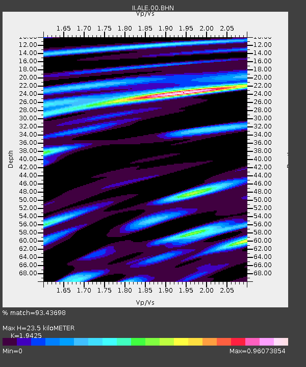
| Estimated Moho Depth: |
23.5 km |
| Estimated Crust Vp/Vs: |
1.94 |
| Assumed Crust Vp: |
6.287 km/s |
| Estimated Crust Vs: |
3.237 km/s |
| Estimated Crust Poisson's Ratio: |
0.32 |
|
| Radial Match: |
93.43698 % |
| Radial Bump: |
400 |
| Transverse Match: |
83.27795 % |
| Transverse Bump: |
400 |
| SOD ConfigId: |
3753 |
| Insert Time: |
2010-03-02 01:15:44.259 +0000 |
| GWidth: |
2.5 |
| Max Bumps: |
400 |
| Tol: |
0.001 |
|

Signal To Noise
| Channel | StoN | STA | LTA |
| II:ALE:00:BHN:20010614T23:42:52.252019Z | 3.583607 | 1.04494006E-7 | 2.915889E-8 |
| II:ALE:00:BHE:20010614T23:42:52.252019Z | 2.491231 | 7.2866115E-8 | 2.9249039E-8 |
| II:ALE:00:BHZ:20010614T23:42:52.252019Z | 7.4707036 | 3.474044E-7 | 4.6502233E-8 |
| Arrivals |
| Ps | 3.6 SECOND |
| PpPs | 11 SECOND |
| PsPs/PpSs | 14 SECOND |


