You are here: Home > Network List > TA - USArray Transportable Network (new EarthScope stations) Stations List
> Station J01E Myrtle Point, OR, USA > Earthquake Result Viewer
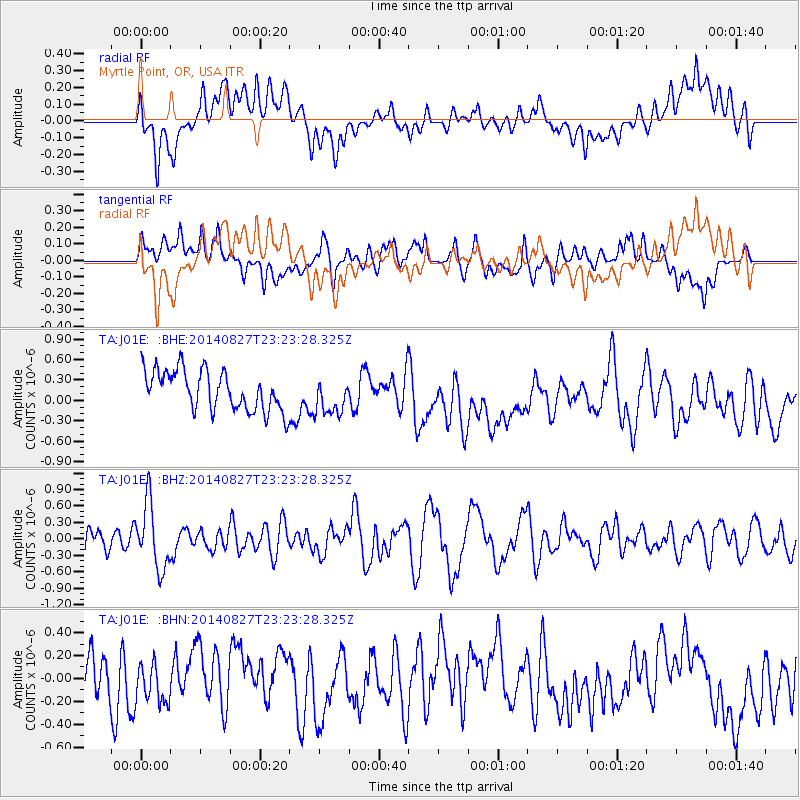
J01E Myrtle Point, OR, USA - Earthquake Result Viewer
*The percent match for this event was below the threshold and hence no stack was calculated.
| Earthquake location: |
Vanuatu Islands |
| Earthquake latitude/longitude: |
-15.1/167.3 |
| Earthquake time(UTC): |
2014/08/27 (239) 23:11:35 GMT |
| Earthquake Depth: |
119 km |
| Earthquake Magnitude: |
5.8 M |
| Earthquake Catalog/Contributor: |
NEIC PDE/NEIC ALERT |
|
| Network: |
TA USArray Transportable Network (new EarthScope stations) |
| Station: |
J01E Myrtle Point, OR, USA |
| Lat/Lon: |
43.16 N/123.93 W |
| Elevation: |
128 m |
|
| Distance: |
85.4 deg |
| Az: |
43.166 deg |
| Baz: |
244.561 deg |
| Ray Param: |
$rayparam |
*The percent match for this event was below the threshold and hence was not used in the summary stack. |
|
| Radial Match: |
50.351772 % |
| Radial Bump: |
400 |
| Transverse Match: |
47.10292 % |
| Transverse Bump: |
400 |
| SOD ConfigId: |
769524 |
| Insert Time: |
2014-09-10 23:30:24.798 +0000 |
| GWidth: |
2.5 |
| Max Bumps: |
400 |
| Tol: |
0.001 |
|
Signal To Noise
| Channel | StoN | STA | LTA |
| TA:J01E: :BHZ:20140827T23:23:28.325Z | 2.63379 | 5.976334E-7 | 2.2691003E-7 |
| TA:J01E: :BHN:20140827T23:23:28.325Z | 0.97553426 | 1.6712995E-7 | 1.7132147E-7 |
| TA:J01E: :BHE:20140827T23:23:28.325Z | 0.9459036 | 2.7577818E-7 | 2.9155E-7 |
| Arrivals |
| Ps | |
| PpPs | |
| PsPs/PpSs | |


