You are here: Home > Network List > TA - USArray Transportable Network (new EarthScope stations) Stations List
> Station J04D Umpqua National Forest, Toketee, OR, USA > Earthquake Result Viewer
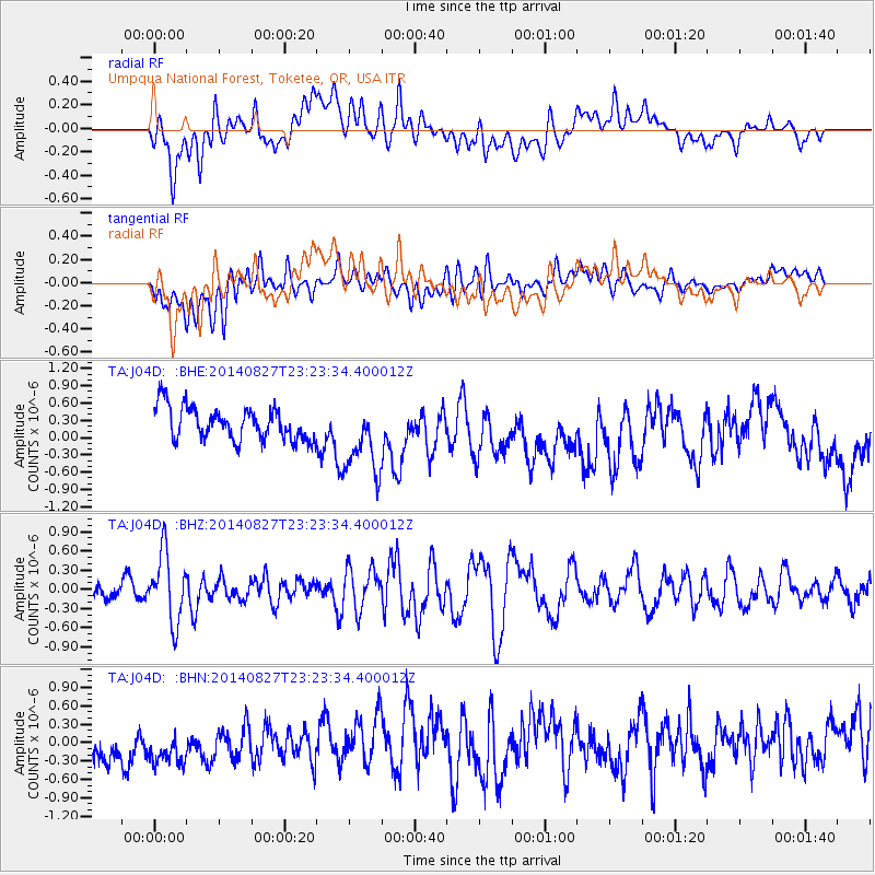
J04D Umpqua National Forest, Toketee, OR, USA - Earthquake Result Viewer
*The percent match for this event was below the threshold and hence no stack was calculated.
| Earthquake location: |
Vanuatu Islands |
| Earthquake latitude/longitude: |
-15.1/167.3 |
| Earthquake time(UTC): |
2014/08/27 (239) 23:11:35 GMT |
| Earthquake Depth: |
119 km |
| Earthquake Magnitude: |
5.8 M |
| Earthquake Catalog/Contributor: |
NEIC PDE/NEIC ALERT |
|
| Network: |
TA USArray Transportable Network (new EarthScope stations) |
| Station: |
J04D Umpqua National Forest, Toketee, OR, USA |
| Lat/Lon: |
43.24 N/122.11 W |
| Elevation: |
1948 m |
|
| Distance: |
86.7 deg |
| Az: |
43.654 deg |
| Baz: |
245.838 deg |
| Ray Param: |
$rayparam |
*The percent match for this event was below the threshold and hence was not used in the summary stack. |
|
| Radial Match: |
38.605755 % |
| Radial Bump: |
400 |
| Transverse Match: |
47.774464 % |
| Transverse Bump: |
400 |
| SOD ConfigId: |
769524 |
| Insert Time: |
2014-09-10 23:30:29.116 +0000 |
| GWidth: |
2.5 |
| Max Bumps: |
400 |
| Tol: |
0.001 |
|
Signal To Noise
| Channel | StoN | STA | LTA |
| TA:J04D: :BHZ:20140827T23:23:34.400012Z | 3.5736818 | 5.3694436E-7 | 1.5024963E-7 |
| TA:J04D: :BHN:20140827T23:23:34.400012Z | 1.1865379 | 4.341614E-7 | 3.6590603E-7 |
| TA:J04D: :BHE:20140827T23:23:34.400012Z | 2.270493 | 6.447066E-7 | 2.8395004E-7 |
| Arrivals |
| Ps | |
| PpPs | |
| PsPs/PpSs | |


