You are here: Home > Network List > TA - USArray Transportable Network (new EarthScope stations) Stations List
> Station O03E Paynes Creek, CA, USA > Earthquake Result Viewer
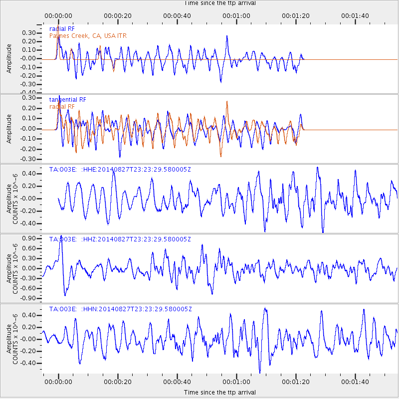
O03E Paynes Creek, CA, USA - Earthquake Result Viewer
*The percent match for this event was below the threshold and hence no stack was calculated.
| Earthquake location: |
Vanuatu Islands |
| Earthquake latitude/longitude: |
-15.1/167.3 |
| Earthquake time(UTC): |
2014/08/27 (239) 23:11:35 GMT |
| Earthquake Depth: |
119 km |
| Earthquake Magnitude: |
5.8 M |
| Earthquake Catalog/Contributor: |
NEIC PDE/NEIC ALERT |
|
| Network: |
TA USArray Transportable Network (new EarthScope stations) |
| Station: |
O03E Paynes Creek, CA, USA |
| Lat/Lon: |
40.29 N/121.80 W |
| Elevation: |
967 m |
|
| Distance: |
85.7 deg |
| Az: |
46.443 deg |
| Baz: |
246.228 deg |
| Ray Param: |
$rayparam |
*The percent match for this event was below the threshold and hence was not used in the summary stack. |
|
| Radial Match: |
61.387966 % |
| Radial Bump: |
398 |
| Transverse Match: |
54.630486 % |
| Transverse Bump: |
400 |
| SOD ConfigId: |
769524 |
| Insert Time: |
2014-09-10 23:30:58.326 +0000 |
| GWidth: |
2.5 |
| Max Bumps: |
400 |
| Tol: |
0.001 |
|
Signal To Noise
| Channel | StoN | STA | LTA |
| TA:O03E: :HHZ:20140827T23:23:29.580005Z | 5.1881304 | 5.3636273E-7 | 1.0338266E-7 |
| TA:O03E: :HHN:20140827T23:23:29.580005Z | 1.1283627 | 9.420316E-8 | 8.34866E-8 |
| TA:O03E: :HHE:20140827T23:23:29.580005Z | 0.88131475 | 1.7199358E-7 | 1.9515568E-7 |
| Arrivals |
| Ps | |
| PpPs | |
| PsPs/PpSs | |


