You are here: Home > Network List > UW - Pacific Northwest Regional Seismic Network Stations List
> Station LEBA Lebam, WA, USA > Earthquake Result Viewer
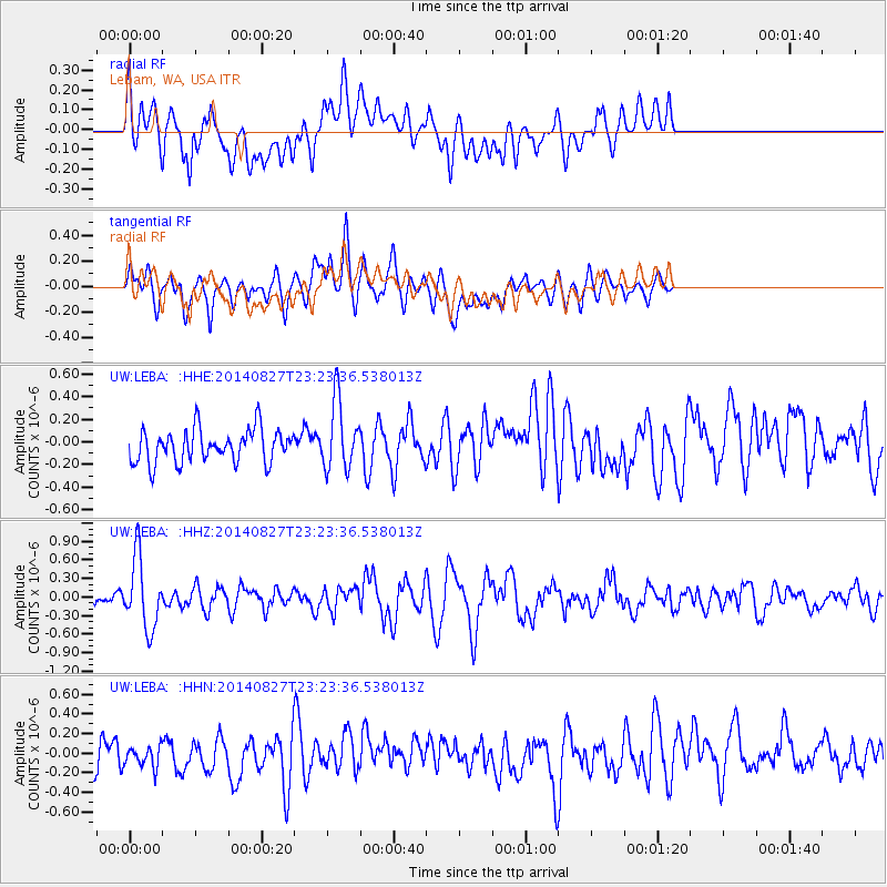
LEBA Lebam, WA, USA - Earthquake Result Viewer
*The percent match for this event was below the threshold and hence no stack was calculated.
| Earthquake location: |
Vanuatu Islands |
| Earthquake latitude/longitude: |
-15.1/167.3 |
| Earthquake time(UTC): |
2014/08/27 (239) 23:11:35 GMT |
| Earthquake Depth: |
119 km |
| Earthquake Magnitude: |
5.8 M |
| Earthquake Catalog/Contributor: |
NEIC PDE/NEIC ALERT |
|
| Network: |
UW Pacific Northwest Regional Seismic Network |
| Station: |
LEBA Lebam, WA, USA |
| Lat/Lon: |
46.55 N/123.56 W |
| Elevation: |
73 m |
|
| Distance: |
87.1 deg |
| Az: |
40.215 deg |
| Baz: |
244.628 deg |
| Ray Param: |
$rayparam |
*The percent match for this event was below the threshold and hence was not used in the summary stack. |
|
| Radial Match: |
64.654175 % |
| Radial Bump: |
400 |
| Transverse Match: |
66.85602 % |
| Transverse Bump: |
400 |
| SOD ConfigId: |
769524 |
| Insert Time: |
2014-09-10 23:36:22.048 +0000 |
| GWidth: |
2.5 |
| Max Bumps: |
400 |
| Tol: |
0.001 |
|
Signal To Noise
| Channel | StoN | STA | LTA |
| UW:LEBA: :HHZ:20140827T23:23:36.538013Z | 5.97763 | 5.673581E-7 | 9.4913545E-8 |
| UW:LEBA: :HHN:20140827T23:23:36.538013Z | 0.53709316 | 1.0633326E-7 | 1.9797916E-7 |
| UW:LEBA: :HHE:20140827T23:23:36.538013Z | 2.0680232 | 3.0362344E-7 | 1.468182E-7 |
| Arrivals |
| Ps | |
| PpPs | |
| PsPs/PpSs | |


