You are here: Home > Network List > IU - Global Seismograph Network (GSN - IRIS/USGS) Stations List
> Station KBL Kabul, Afghanistan > Earthquake Result Viewer
KBL Kabul, Afghanistan - Earthquake Result Viewer
| Earthquake location: |
Shikoku, Japan |
| Earthquake latitude/longitude: |
32.1/132.1 |
| Earthquake time(UTC): |
2014/08/28 (240) 19:14:35 GMT |
| Earthquake Depth: |
22 km |
| Earthquake Magnitude: |
5.8 MWB |
| Earthquake Catalog/Contributor: |
NEIC PDE/NEIC COMCAT |
|
| Network: |
IU Global Seismograph Network (GSN - IRIS/USGS) |
| Station: |
KBL Kabul, Afghanistan |
| Lat/Lon: |
34.54 N/69.04 E |
| Elevation: |
1920 m |
|
| Distance: |
52.0 deg |
| Az: |
290.921 deg |
| Baz: |
73.832 deg |
| Ray Param: |
0.06702124 |
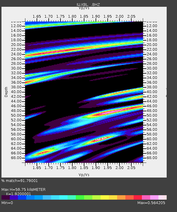
| Estimated Moho Depth: |
59.75 km |
| Estimated Crust Vp/Vs: |
1.92 |
| Assumed Crust Vp: |
6.641 km/s |
| Estimated Crust Vs: |
3.459 km/s |
| Estimated Crust Poisson's Ratio: |
0.31 |
|
| Radial Match: |
91.79001 % |
| Radial Bump: |
400 |
| Transverse Match: |
80.94473 % |
| Transverse Bump: |
400 |
| SOD ConfigId: |
769524 |
| Insert Time: |
2014-09-11 19:45:41.985 +0000 |
| GWidth: |
2.5 |
| Max Bumps: |
400 |
| Tol: |
0.001 |
|
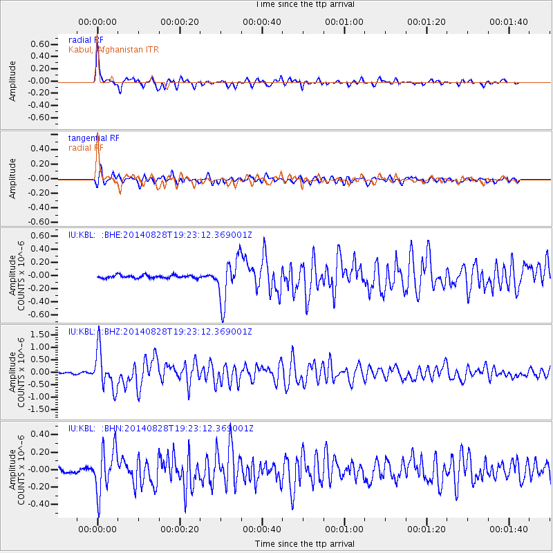
Signal To Noise
| Channel | StoN | STA | LTA |
| IU:KBL: :BHZ:20140828T19:23:12.369001Z | 29.687654 | 8.0665853E-7 | 2.7171515E-8 |
| IU:KBL: :BHN:20140828T19:23:12.369001Z | 11.375832 | 2.628225E-7 | 2.3103585E-8 |
| IU:KBL: :BHE:20140828T19:23:12.369001Z | 14.932856 | 3.4461357E-7 | 2.307754E-8 |
| Arrivals |
| Ps | 8.7 SECOND |
| PpPs | 25 SECOND |
| PsPs/PpSs | 34 SECOND |


