You are here: Home > Network List > YT07 - POLENET Stations List
> Station UNGL UNGL > Earthquake Result Viewer
UNGL UNGL - Earthquake Result Viewer
| Earthquake location: |
South Island, New Zealand |
| Earthquake latitude/longitude: |
-42.1/173.0 |
| Earthquake time(UTC): |
2015/04/24 (114) 03:36:43 GMT |
| Earthquake Depth: |
55 km |
| Earthquake Magnitude: |
5.9 MWP |
| Earthquake Catalog/Contributor: |
NEIC PDE/NEIC COMCAT |
|
| Network: |
YT POLENET |
| Station: |
UNGL UNGL |
| Lat/Lon: |
79.77 S/82.52 W |
| Elevation: |
745 m |
|
| Distance: |
51.4 deg |
| Az: |
167.212 deg |
| Baz: |
247.257 deg |
| Ray Param: |
0.067282505 |
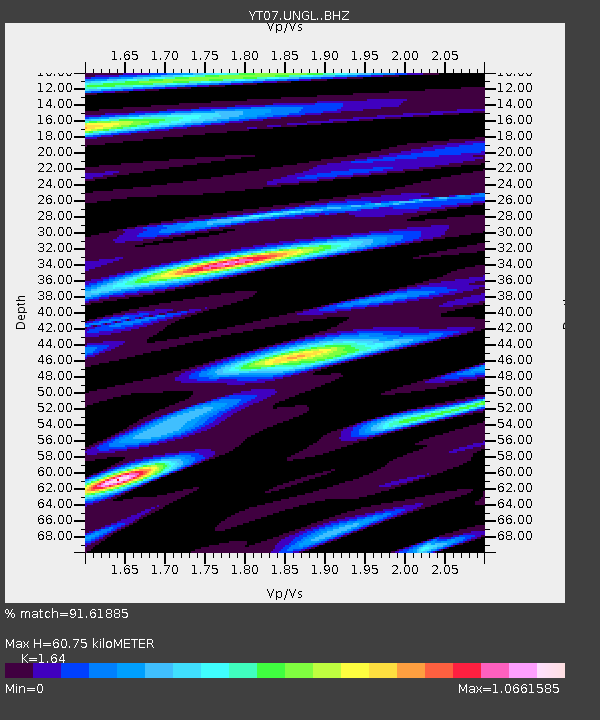
| Estimated Moho Depth: |
60.75 km |
| Estimated Crust Vp/Vs: |
1.64 |
| Assumed Crust Vp: |
6.182 km/s |
| Estimated Crust Vs: |
3.769 km/s |
| Estimated Crust Poisson's Ratio: |
0.20 |
|
| Radial Match: |
91.61885 % |
| Radial Bump: |
364 |
| Transverse Match: |
85.91658 % |
| Transverse Bump: |
400 |
| SOD ConfigId: |
7422571 |
| Insert Time: |
2019-04-18 08:19:07.260 +0000 |
| GWidth: |
2.5 |
| Max Bumps: |
400 |
| Tol: |
0.001 |
|

Signal To Noise
| Channel | StoN | STA | LTA |
| YT:UNGL: :BHZ:20150424T03:45:11.174988Z | 12.343761 | 1.2841286E-6 | 1.0403058E-7 |
| YT:UNGL: :BHN:20150424T03:45:11.174988Z | 2.4040396 | 2.5026407E-7 | 1.0410147E-7 |
| YT:UNGL: :BHE:20150424T03:45:11.174988Z | 3.2764237 | 5.749568E-7 | 1.7548304E-7 |
| Arrivals |
| Ps | 6.7 SECOND |
| PpPs | 25 SECOND |
| PsPs/PpSs | 31 SECOND |


