You are here: Home > Network List > ZJ12 - Transantarctic Mountains Northern Network Stations List
> Station SAMH East Antarctica > Earthquake Result Viewer
SAMH East Antarctica - Earthquake Result Viewer
| Earthquake location: |
South Island, New Zealand |
| Earthquake latitude/longitude: |
-42.1/173.0 |
| Earthquake time(UTC): |
2015/04/24 (114) 03:36:43 GMT |
| Earthquake Depth: |
55 km |
| Earthquake Magnitude: |
5.9 MWP |
| Earthquake Catalog/Contributor: |
NEIC PDE/NEIC COMCAT |
|
| Network: |
ZJ Transantarctic Mountains Northern Network |
| Station: |
SAMH East Antarctica |
| Lat/Lon: |
75.20 S/154.00 E |
| Elevation: |
2087 m |
|
| Distance: |
34.3 deg |
| Az: |
188.547 deg |
| Baz: |
25.501 deg |
| Ray Param: |
0.0776712 |
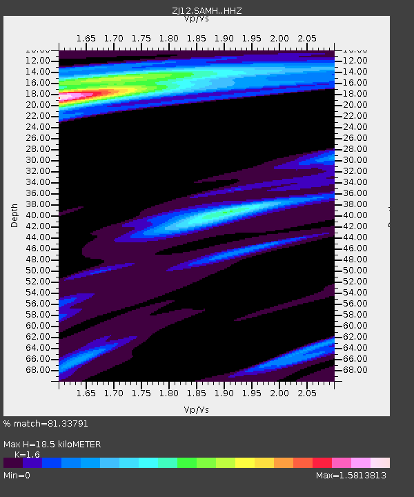
| Estimated Moho Depth: |
18.5 km |
| Estimated Crust Vp/Vs: |
1.60 |
| Assumed Crust Vp: |
6.262 km/s |
| Estimated Crust Vs: |
3.914 km/s |
| Estimated Crust Poisson's Ratio: |
0.18 |
|
| Radial Match: |
81.33791 % |
| Radial Bump: |
400 |
| Transverse Match: |
77.110405 % |
| Transverse Bump: |
400 |
| SOD ConfigId: |
7422571 |
| Insert Time: |
2019-04-18 08:19:18.116 +0000 |
| GWidth: |
2.5 |
| Max Bumps: |
400 |
| Tol: |
0.001 |
|

Signal To Noise
| Channel | StoN | STA | LTA |
| ZJ:SAMH: :HHZ:20150424T03:42:53.248993Z | 5.987914 | 1.6036336E-6 | 2.678117E-7 |
| ZJ:SAMH: :HHN:20150424T03:42:53.248993Z | 2.6875587 | 6.3887694E-7 | 2.3771646E-7 |
| ZJ:SAMH: :HHE:20150424T03:42:53.248993Z | 1.5626075 | 3.7922027E-7 | 2.4268428E-7 |
| Arrivals |
| Ps | 1.9 SECOND |
| PpPs | 7.1 SECOND |
| PsPs/PpSs | 9.0 SECOND |


