You are here: Home > Network List > TA - USArray Transportable Network (new EarthScope stations) Stations List
> Station K27K Chicken, AK, USA > Earthquake Result Viewer
K27K Chicken, AK, USA - Earthquake Result Viewer
| Earthquake location: |
Shikoku, Japan |
| Earthquake latitude/longitude: |
32.1/132.1 |
| Earthquake time(UTC): |
2014/08/28 (240) 19:14:35 GMT |
| Earthquake Depth: |
22 km |
| Earthquake Magnitude: |
5.8 MWB |
| Earthquake Catalog/Contributor: |
NEIC PDE/NEIC COMCAT |
|
| Network: |
TA USArray Transportable Network (new EarthScope stations) |
| Station: |
K27K Chicken, AK, USA |
| Lat/Lon: |
64.03 N/142.08 W |
| Elevation: |
389 m |
|
| Distance: |
59.9 deg |
| Az: |
30.511 deg |
| Baz: |
281.827 deg |
| Ray Param: |
0.06187462 |
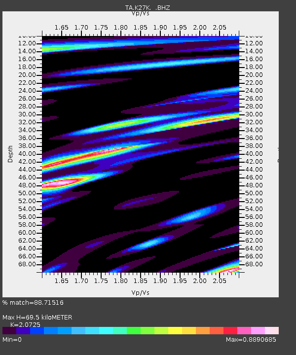
| Estimated Moho Depth: |
69.5 km |
| Estimated Crust Vp/Vs: |
2.07 |
| Assumed Crust Vp: |
6.566 km/s |
| Estimated Crust Vs: |
3.168 km/s |
| Estimated Crust Poisson's Ratio: |
0.35 |
|
| Radial Match: |
88.71516 % |
| Radial Bump: |
400 |
| Transverse Match: |
61.999813 % |
| Transverse Bump: |
400 |
| SOD ConfigId: |
769524 |
| Insert Time: |
2014-09-11 19:58:56.262 +0000 |
| GWidth: |
2.5 |
| Max Bumps: |
400 |
| Tol: |
0.001 |
|

Signal To Noise
| Channel | StoN | STA | LTA |
| TA:K27K: :BHZ:20140828T19:24:08.72502Z | 5.5480595 | 3.8281652E-7 | 6.900008E-8 |
| TA:K27K: :BHN:20140828T19:24:08.72502Z | 0.8346691 | 8.9030536E-8 | 1.0666567E-7 |
| TA:K27K: :BHE:20140828T19:24:08.72502Z | 2.945942 | 1.5614341E-7 | 5.3002886E-8 |
| Arrivals |
| Ps | 12 SECOND |
| PpPs | 31 SECOND |
| PsPs/PpSs | 43 SECOND |


