You are here: Home > Network List > TA - USArray Transportable Network (new EarthScope stations) Stations List
> Station K61A Williamstown, MA, USA > Earthquake Result Viewer
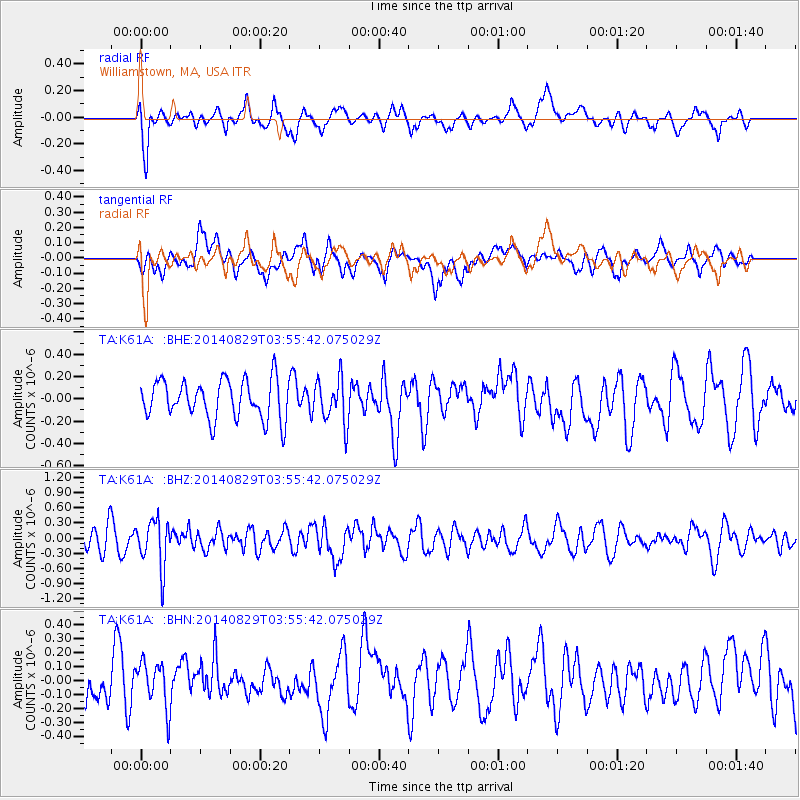
K61A Williamstown, MA, USA - Earthquake Result Viewer
*The percent match for this event was below the threshold and hence no stack was calculated.
| Earthquake location: |
Southern Greece |
| Earthquake latitude/longitude: |
36.7/23.8 |
| Earthquake time(UTC): |
2014/08/29 (241) 03:45:06 GMT |
| Earthquake Depth: |
92 km |
| Earthquake Magnitude: |
5.6 MB |
| Earthquake Catalog/Contributor: |
NEIC PDE/NEIC COMCAT |
|
| Network: |
TA USArray Transportable Network (new EarthScope stations) |
| Station: |
K61A Williamstown, MA, USA |
| Lat/Lon: |
42.67 N/73.27 W |
| Elevation: |
391 m |
|
| Distance: |
70.7 deg |
| Az: |
309.162 deg |
| Baz: |
57.618 deg |
| Ray Param: |
$rayparam |
*The percent match for this event was below the threshold and hence was not used in the summary stack. |
|
| Radial Match: |
49.486385 % |
| Radial Bump: |
400 |
| Transverse Match: |
42.091373 % |
| Transverse Bump: |
400 |
| SOD ConfigId: |
769524 |
| Insert Time: |
2014-09-12 04:11:49.138 +0000 |
| GWidth: |
2.5 |
| Max Bumps: |
400 |
| Tol: |
0.001 |
|
Signal To Noise
| Channel | StoN | STA | LTA |
| TA:K61A: :BHZ:20140829T03:55:42.075029Z | 2.351519 | 4.6813162E-7 | 1.9907625E-7 |
| TA:K61A: :BHN:20140829T03:55:42.075029Z | 1.0406773 | 1.6556069E-7 | 1.5908937E-7 |
| TA:K61A: :BHE:20140829T03:55:42.075029Z | 1.1595557 | 2.0229282E-7 | 1.7445718E-7 |
| Arrivals |
| Ps | |
| PpPs | |
| PsPs/PpSs | |


