You are here: Home > Network List > TA - USArray Transportable Network (new EarthScope stations) Stations List
> Station M52A Chesterland, OH, USA > Earthquake Result Viewer
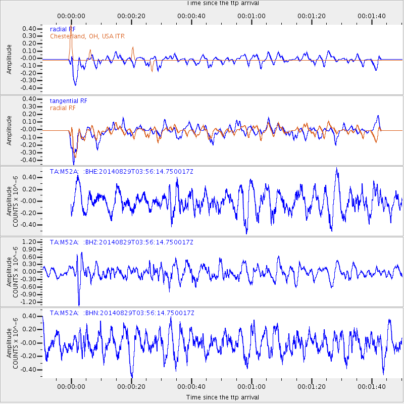
M52A Chesterland, OH, USA - Earthquake Result Viewer
*The percent match for this event was below the threshold and hence no stack was calculated.
| Earthquake location: |
Southern Greece |
| Earthquake latitude/longitude: |
36.7/23.8 |
| Earthquake time(UTC): |
2014/08/29 (241) 03:45:06 GMT |
| Earthquake Depth: |
92 km |
| Earthquake Magnitude: |
5.6 MB |
| Earthquake Catalog/Contributor: |
NEIC PDE/NEIC COMCAT |
|
| Network: |
TA USArray Transportable Network (new EarthScope stations) |
| Station: |
M52A Chesterland, OH, USA |
| Lat/Lon: |
41.54 N/81.36 W |
| Elevation: |
382 m |
|
| Distance: |
76.3 deg |
| Az: |
311.769 deg |
| Baz: |
52.949 deg |
| Ray Param: |
$rayparam |
*The percent match for this event was below the threshold and hence was not used in the summary stack. |
|
| Radial Match: |
56.596184 % |
| Radial Bump: |
400 |
| Transverse Match: |
53.7455 % |
| Transverse Bump: |
400 |
| SOD ConfigId: |
769524 |
| Insert Time: |
2014-09-12 04:12:34.845 +0000 |
| GWidth: |
2.5 |
| Max Bumps: |
400 |
| Tol: |
0.001 |
|
Signal To Noise
| Channel | StoN | STA | LTA |
| TA:M52A: :BHZ:20140829T03:56:14.750017Z | 3.522839 | 4.615857E-7 | 1.3102662E-7 |
| TA:M52A: :BHN:20140829T03:56:14.750017Z | 0.6307763 | 1.00988174E-7 | 1.6010141E-7 |
| TA:M52A: :BHE:20140829T03:56:14.750017Z | 1.0434468 | 1.5684769E-7 | 1.5031691E-7 |
| Arrivals |
| Ps | |
| PpPs | |
| PsPs/PpSs | |


