You are here: Home > Network List > TA - USArray Transportable Network (new EarthScope stations) Stations List
> Station N51A Ashland, OH, USA > Earthquake Result Viewer
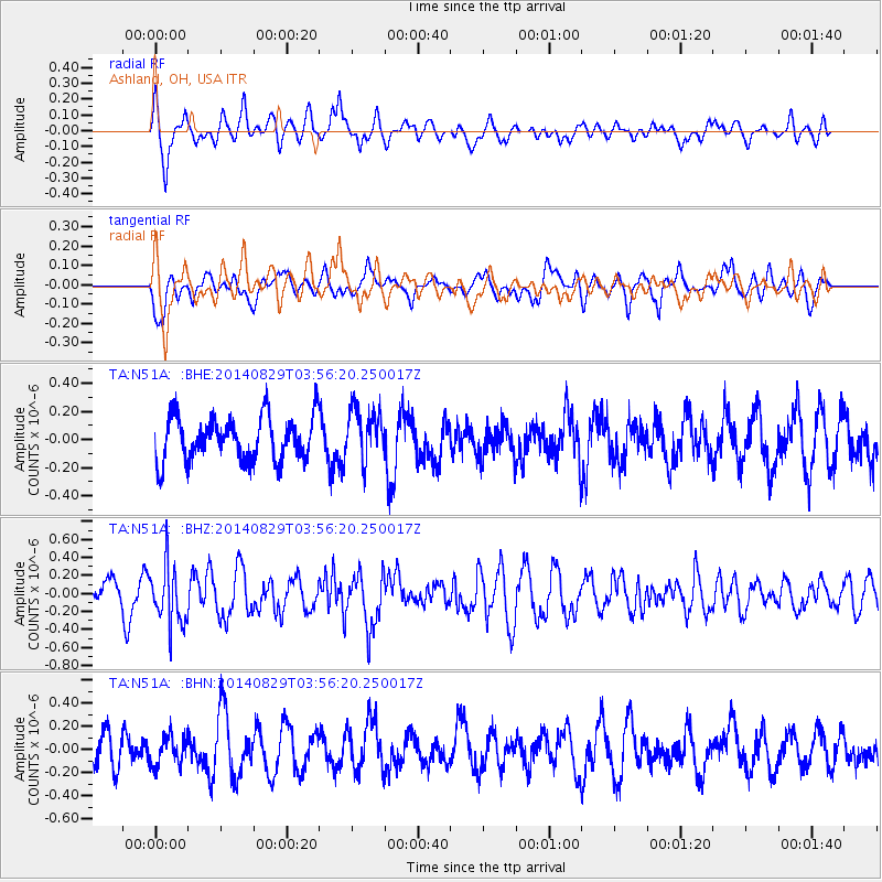
N51A Ashland, OH, USA - Earthquake Result Viewer
*The percent match for this event was below the threshold and hence no stack was calculated.
| Earthquake location: |
Southern Greece |
| Earthquake latitude/longitude: |
36.7/23.8 |
| Earthquake time(UTC): |
2014/08/29 (241) 03:45:06 GMT |
| Earthquake Depth: |
92 km |
| Earthquake Magnitude: |
5.6 MB |
| Earthquake Catalog/Contributor: |
NEIC PDE/NEIC COMCAT |
|
| Network: |
TA USArray Transportable Network (new EarthScope stations) |
| Station: |
N51A Ashland, OH, USA |
| Lat/Lon: |
40.92 N/82.37 W |
| Elevation: |
343 m |
|
| Distance: |
77.3 deg |
| Az: |
311.741 deg |
| Baz: |
52.274 deg |
| Ray Param: |
$rayparam |
*The percent match for this event was below the threshold and hence was not used in the summary stack. |
|
| Radial Match: |
73.73728 % |
| Radial Bump: |
400 |
| Transverse Match: |
48.89918 % |
| Transverse Bump: |
354 |
| SOD ConfigId: |
769524 |
| Insert Time: |
2014-09-12 04:13:03.611 +0000 |
| GWidth: |
2.5 |
| Max Bumps: |
400 |
| Tol: |
0.001 |
|
Signal To Noise
| Channel | StoN | STA | LTA |
| TA:N51A: :BHZ:20140829T03:56:20.250017Z | 2.3634927 | 3.354358E-7 | 1.4192376E-7 |
| TA:N51A: :BHN:20140829T03:56:20.250017Z | 0.7042894 | 1.2663115E-7 | 1.7979988E-7 |
| TA:N51A: :BHE:20140829T03:56:20.250017Z | 1.1600711 | 1.8447444E-7 | 1.5901995E-7 |
| Arrivals |
| Ps | |
| PpPs | |
| PsPs/PpSs | |


