You are here: Home > Network List > TA - USArray Transportable Network (new EarthScope stations) Stations List
> Station T56A Rocky Mt, VA, USA > Earthquake Result Viewer
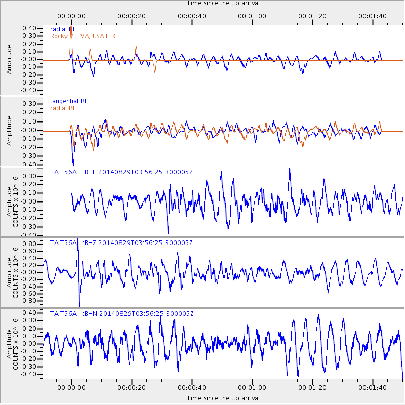
T56A Rocky Mt, VA, USA - Earthquake Result Viewer
*The percent match for this event was below the threshold and hence no stack was calculated.
| Earthquake location: |
Southern Greece |
| Earthquake latitude/longitude: |
36.7/23.8 |
| Earthquake time(UTC): |
2014/08/29 (241) 03:45:06 GMT |
| Earthquake Depth: |
92 km |
| Earthquake Magnitude: |
5.6 MB |
| Earthquake Catalog/Contributor: |
NEIC PDE/NEIC COMCAT |
|
| Network: |
TA USArray Transportable Network (new EarthScope stations) |
| Station: |
T56A Rocky Mt, VA, USA |
| Lat/Lon: |
37.03 N/80.03 W |
| Elevation: |
387 m |
|
| Distance: |
78.2 deg |
| Az: |
307.449 deg |
| Baz: |
52.834 deg |
| Ray Param: |
$rayparam |
*The percent match for this event was below the threshold and hence was not used in the summary stack. |
|
| Radial Match: |
55.85225 % |
| Radial Bump: |
400 |
| Transverse Match: |
67.21689 % |
| Transverse Bump: |
400 |
| SOD ConfigId: |
769524 |
| Insert Time: |
2014-09-12 04:14:48.091 +0000 |
| GWidth: |
2.5 |
| Max Bumps: |
400 |
| Tol: |
0.001 |
|
Signal To Noise
| Channel | StoN | STA | LTA |
| TA:T56A: :BHZ:20140829T03:56:25.300005Z | 2.019831 | 3.4942664E-7 | 1.7299796E-7 |
| TA:T56A: :BHN:20140829T03:56:25.300005Z | 0.6825318 | 9.221339E-8 | 1.351049E-7 |
| TA:T56A: :BHE:20140829T03:56:25.300005Z | 1.447463 | 1.1516602E-7 | 7.956405E-8 |
| Arrivals |
| Ps | |
| PpPs | |
| PsPs/PpSs | |


