You are here: Home > Network List > N4 - Central and EAstern US Network Stations List
> Station 152A Waverly Hall, GA, USA > Earthquake Result Viewer
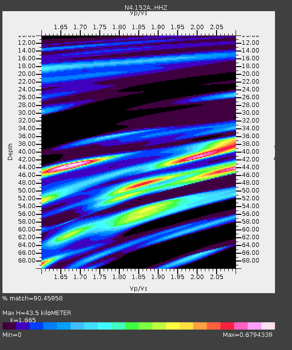
152A Waverly Hall, GA, USA - Earthquake Result Viewer
| Earthquake location: |
Queen Charlotte Islands Region |
| Earthquake latitude/longitude: |
51.7/-130.8 |
| Earthquake time(UTC): |
2015/04/24 (114) 13:56:16 GMT |
| Earthquake Depth: |
10 km |
| Earthquake Magnitude: |
6.1 MO |
| Earthquake Catalog/Contributor: |
NEIC PDE/NEIC ALERT |
|
| Network: |
N4 Central and EAstern US Network |
| Station: |
152A Waverly Hall, GA, USA |
| Lat/Lon: |
32.67 N/84.72 W |
| Elevation: |
214 m |
|
| Distance: |
38.3 deg |
| Az: |
101.592 deg |
| Baz: |
313.763 deg |
| Ray Param: |
0.07564453 |
| Estimated Moho Depth: |
43.5 km |
| Estimated Crust Vp/Vs: |
1.66 |
| Assumed Crust Vp: |
6.719 km/s |
| Estimated Crust Vs: |
4.036 km/s |
| Estimated Crust Poisson's Ratio: |
0.22 |
|
| Radial Match: |
90.45958 % |
| Radial Bump: |
305 |
| Transverse Match: |
41.93611 % |
| Transverse Bump: |
400 |
| SOD ConfigId: |
7422571 |
| Insert Time: |
2019-04-18 08:24:51.290 +0000 |
| GWidth: |
2.5 |
| Max Bumps: |
400 |
| Tol: |
0.001 |
|

Signal To Noise
| Channel | StoN | STA | LTA |
| N4:152A: :HHZ:20150424T14:03:06.269989Z | 5.6237116 | 4.836197E-7 | 8.599654E-8 |
| N4:152A: :HHN:20150424T14:03:06.269989Z | 1.1241487 | 2.5655405E-7 | 2.2822073E-7 |
| N4:152A: :HHE:20150424T14:03:06.269989Z | 1.2580098 | 2.5682186E-7 | 2.0414934E-7 |
| Arrivals |
| Ps | 4.7 SECOND |
| PpPs | 16 SECOND |
| PsPs/PpSs | 21 SECOND |


