You are here: Home > Network List > TA - USArray Transportable Network (new EarthScope stations) Stations List
> Station M54A Oil Creek State Park, Oil City, PA, USA > Earthquake Result Viewer
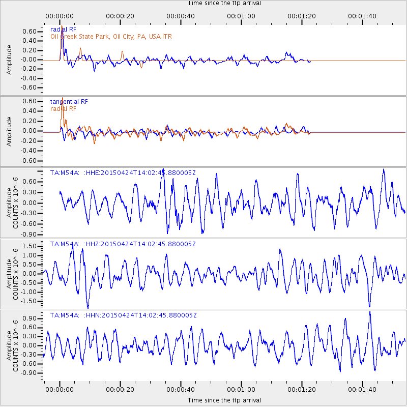
M54A Oil Creek State Park, Oil City, PA, USA - Earthquake Result Viewer
*The percent match for this event was below the threshold and hence no stack was calculated.
| Earthquake location: |
Queen Charlotte Islands Region |
| Earthquake latitude/longitude: |
51.7/-130.8 |
| Earthquake time(UTC): |
2015/04/24 (114) 13:56:16 GMT |
| Earthquake Depth: |
10 km |
| Earthquake Magnitude: |
6.1 MO |
| Earthquake Catalog/Contributor: |
NEIC PDE/NEIC ALERT |
|
| Network: |
TA USArray Transportable Network (new EarthScope stations) |
| Station: |
M54A Oil Creek State Park, Oil City, PA, USA |
| Lat/Lon: |
41.51 N/79.66 W |
| Elevation: |
488 m |
|
| Distance: |
35.9 deg |
| Az: |
85.98 deg |
| Baz: |
304.322 deg |
| Ray Param: |
$rayparam |
*The percent match for this event was below the threshold and hence was not used in the summary stack. |
|
| Radial Match: |
68.17942 % |
| Radial Bump: |
312 |
| Transverse Match: |
61.52293 % |
| Transverse Bump: |
262 |
| SOD ConfigId: |
7422571 |
| Insert Time: |
2019-04-18 08:26:51.865 +0000 |
| GWidth: |
2.5 |
| Max Bumps: |
400 |
| Tol: |
0.001 |
|
Signal To Noise
| Channel | StoN | STA | LTA |
| TA:M54A: :HHZ:20150424T14:02:45.880005Z | 2.1281366 | 6.709723E-7 | 3.1528631E-7 |
| TA:M54A: :HHN:20150424T14:02:45.880005Z | 1.0926117 | 2.5971778E-7 | 2.3770365E-7 |
| TA:M54A: :HHE:20150424T14:02:45.880005Z | 1.42051 | 3.2582875E-7 | 2.2937449E-7 |
| Arrivals |
| Ps | |
| PpPs | |
| PsPs/PpSs | |


