You are here: Home > Network List > CI - Caltech Regional Seismic Network Stations List
> Station ISA Isabella > Earthquake Result Viewer
ISA Isabella - Earthquake Result Viewer
| Earthquake location: |
Kermadec Islands Region |
| Earthquake latitude/longitude: |
-31.9/-179.0 |
| Earthquake time(UTC): |
1999/04/20 (110) 19:04:08 GMT |
| Earthquake Depth: |
96 km |
| Earthquake Magnitude: |
6.2 MB, 6.5 MW, 6.5 MW |
| Earthquake Catalog/Contributor: |
WHDF/NEIC |
|
| Network: |
CI Caltech Regional Seismic Network |
| Station: |
ISA Isabella |
| Lat/Lon: |
35.66 N/118.47 W |
| Elevation: |
873 m |
|
| Distance: |
88.0 deg |
| Az: |
45.206 deg |
| Baz: |
227.845 deg |
| Ray Param: |
0.042730056 |
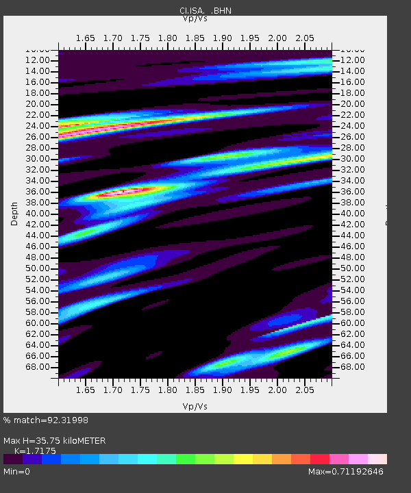
| Estimated Moho Depth: |
35.75 km |
| Estimated Crust Vp/Vs: |
1.72 |
| Assumed Crust Vp: |
6.1 km/s |
| Estimated Crust Vs: |
3.552 km/s |
| Estimated Crust Poisson's Ratio: |
0.24 |
|
| Radial Match: |
92.31998 % |
| Radial Bump: |
400 |
| Transverse Match: |
88.990685 % |
| Transverse Bump: |
400 |
| SOD ConfigId: |
3787 |
| Insert Time: |
2010-02-25 21:15:19.595 +0000 |
| GWidth: |
2.5 |
| Max Bumps: |
400 |
| Tol: |
0.001 |
|

Signal To Noise
| Channel | StoN | STA | LTA |
| CI:ISA: :BHN:19990420T19:16:16.452996Z | 1.3130957 | 2.086062E-7 | 1.5886596E-7 |
| CI:ISA: :BHE:19990420T19:16:16.452996Z | 4.3787293 | 4.839999E-7 | 1.10534316E-7 |
| CI:ISA: :BHZ:19990420T19:16:16.452996Z | 19.159855 | 1.9126912E-6 | 9.9828064E-8 |
| Arrivals |
| Ps | 4.3 SECOND |
| PpPs | 16 SECOND |
| PsPs/PpSs | 20 SECOND |


