You are here: Home > Network List > TA - USArray Transportable Network (new EarthScope stations) Stations List
> Station SFIN Lafayette, IN, USA > Earthquake Result Viewer
SFIN Lafayette, IN, USA - Earthquake Result Viewer
| Earthquake location: |
Queen Charlotte Islands Region |
| Earthquake latitude/longitude: |
51.7/-130.8 |
| Earthquake time(UTC): |
2015/04/24 (114) 13:56:16 GMT |
| Earthquake Depth: |
10 km |
| Earthquake Magnitude: |
6.1 MO |
| Earthquake Catalog/Contributor: |
NEIC PDE/NEIC ALERT |
|
| Network: |
TA USArray Transportable Network (new EarthScope stations) |
| Station: |
SFIN Lafayette, IN, USA |
| Lat/Lon: |
40.38 N/87.10 W |
| Elevation: |
165 m |
|
| Distance: |
31.9 deg |
| Az: |
93.427 deg |
| Baz: |
305.655 deg |
| Ray Param: |
0.07888467 |
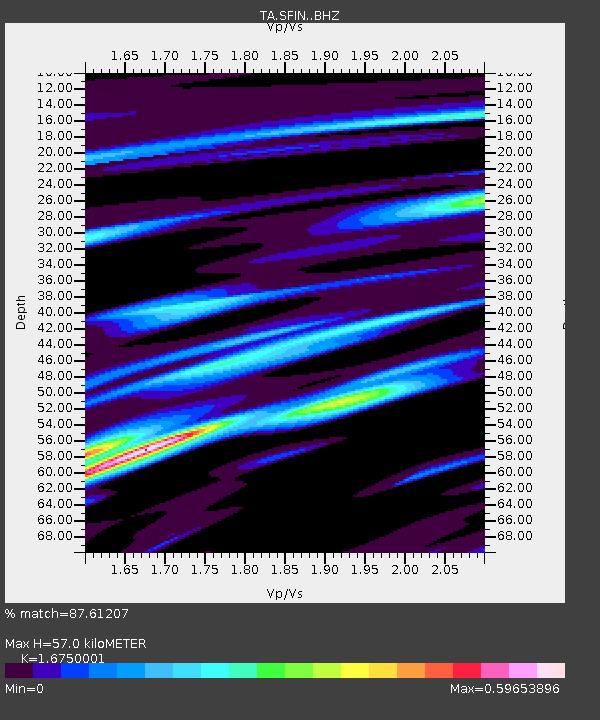
| Estimated Moho Depth: |
57.0 km |
| Estimated Crust Vp/Vs: |
1.68 |
| Assumed Crust Vp: |
6.498 km/s |
| Estimated Crust Vs: |
3.879 km/s |
| Estimated Crust Poisson's Ratio: |
0.22 |
|
| Radial Match: |
87.61207 % |
| Radial Bump: |
298 |
| Transverse Match: |
66.26959 % |
| Transverse Bump: |
388 |
| SOD ConfigId: |
7422571 |
| Insert Time: |
2019-04-18 08:27:12.088 +0000 |
| GWidth: |
2.5 |
| Max Bumps: |
400 |
| Tol: |
0.001 |
|

Signal To Noise
| Channel | StoN | STA | LTA |
| TA:SFIN: :BHZ:20150424T14:02:11.373993Z | 3.084384 | 7.41198E-7 | 2.4030666E-7 |
| TA:SFIN: :BHN:20150424T14:02:11.373993Z | 1.0005451 | 2.029392E-7 | 2.0282864E-7 |
| TA:SFIN: :BHE:20150424T14:02:11.373993Z | 1.9679623 | 3.0537677E-7 | 1.551741E-7 |
| Arrivals |
| Ps | 6.5 SECOND |
| PpPs | 22 SECOND |
| PsPs/PpSs | 28 SECOND |


