You are here: Home > Network List > TA - USArray Transportable Network (new EarthScope stations) Stations List
> Station X43A Marvell, AR, USA > Earthquake Result Viewer
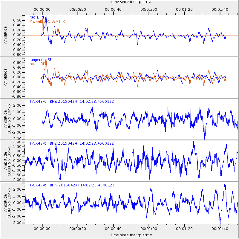
X43A Marvell, AR, USA - Earthquake Result Viewer
*The percent match for this event was below the threshold and hence no stack was calculated.
| Earthquake location: |
Queen Charlotte Islands Region |
| Earthquake latitude/longitude: |
51.7/-130.8 |
| Earthquake time(UTC): |
2015/04/24 (114) 13:56:16 GMT |
| Earthquake Depth: |
10 km |
| Earthquake Magnitude: |
6.1 MO |
| Earthquake Catalog/Contributor: |
NEIC PDE/NEIC ALERT |
|
| Network: |
TA USArray Transportable Network (new EarthScope stations) |
| Station: |
X43A Marvell, AR, USA |
| Lat/Lon: |
34.52 N/90.88 W |
| Elevation: |
53 m |
|
| Distance: |
33.3 deg |
| Az: |
105.375 deg |
| Baz: |
313.438 deg |
| Ray Param: |
$rayparam |
*The percent match for this event was below the threshold and hence was not used in the summary stack. |
|
| Radial Match: |
75.553856 % |
| Radial Bump: |
396 |
| Transverse Match: |
60.76879 % |
| Transverse Bump: |
400 |
| SOD ConfigId: |
7422571 |
| Insert Time: |
2019-04-18 08:27:16.182 +0000 |
| GWidth: |
2.5 |
| Max Bumps: |
400 |
| Tol: |
0.001 |
|
Signal To Noise
| Channel | StoN | STA | LTA |
| TA:X43A: :BHZ:20150424T14:02:23.450012Z | 2.1888962 | 6.57846E-7 | 3.0053775E-7 |
| TA:X43A: :BHN:20150424T14:02:23.450012Z | 1.2228049 | 5.954438E-7 | 4.8694915E-7 |
| TA:X43A: :BHE:20150424T14:02:23.450012Z | 1.4342195 | 7.8011357E-7 | 5.43929E-7 |
| Arrivals |
| Ps | |
| PpPs | |
| PsPs/PpSs | |


