You are here: Home > Network List > XL12 - Hangay Dome, Mongolia Stations List
> Station HV21 HV21 > Earthquake Result Viewer
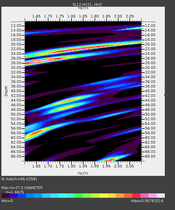
HV21 HV21 - Earthquake Result Viewer
| Earthquake location: |
Queen Charlotte Islands Region |
| Earthquake latitude/longitude: |
51.7/-130.8 |
| Earthquake time(UTC): |
2015/04/24 (114) 13:56:16 GMT |
| Earthquake Depth: |
10 km |
| Earthquake Magnitude: |
6.1 MO |
| Earthquake Catalog/Contributor: |
NEIC PDE/NEIC ALERT |
|
| Network: |
XL Hangay Dome, Mongolia |
| Station: |
HV21 HV21 |
| Lat/Lon: |
51.43 N/100.78 E |
| Elevation: |
1677 m |
|
| Distance: |
68.4 deg |
| Az: |
328.178 deg |
| Baz: |
31.582 deg |
| Ray Param: |
0.056344304 |
| Estimated Moho Depth: |
27.0 km |
| Estimated Crust Vp/Vs: |
1.66 |
| Assumed Crust Vp: |
6.419 km/s |
| Estimated Crust Vs: |
3.861 km/s |
| Estimated Crust Poisson's Ratio: |
0.22 |
|
| Radial Match: |
96.42591 % |
| Radial Bump: |
291 |
| Transverse Match: |
88.30696 % |
| Transverse Bump: |
400 |
| SOD ConfigId: |
7422571 |
| Insert Time: |
2019-04-18 08:28:15.919 +0000 |
| GWidth: |
2.5 |
| Max Bumps: |
400 |
| Tol: |
0.001 |
|

Signal To Noise
| Channel | StoN | STA | LTA |
| XL:HV21: :HHZ:20150424T14:06:46.869995Z | 18.881927 | 6.676705E-7 | 3.5360294E-8 |
| XL:HV21: :HHN:20150424T14:06:46.869995Z | 16.558012 | 2.7286276E-7 | 1.6479198E-8 |
| XL:HV21: :HHE:20150424T14:06:46.869995Z | 5.7674193 | 1.4663685E-7 | 2.5425038E-8 |
| Arrivals |
| Ps | 2.9 SECOND |
| PpPs | 11 SECOND |
| PsPs/PpSs | 14 SECOND |


