You are here: Home > Network List > NM - Cooperative New Madrid Seismic Network Stations List
> Station UTMT Martin, TN > Earthquake Result Viewer
UTMT Martin, TN - Earthquake Result Viewer
| Earthquake location: |
Central East Pacific Rise |
| Earthquake latitude/longitude: |
-11.6/-112.0 |
| Earthquake time(UTC): |
2014/09/02 (245) 23:41:31 GMT |
| Earthquake Depth: |
10 km |
| Earthquake Magnitude: |
5.5 MWP |
| Earthquake Catalog/Contributor: |
NEIC PDE/NEIC COMCAT |
|
| Network: |
NM Cooperative New Madrid Seismic Network |
| Station: |
UTMT Martin, TN |
| Lat/Lon: |
36.35 N/88.86 W |
| Elevation: |
110 m |
|
| Distance: |
52.4 deg |
| Az: |
23.601 deg |
| Baz: |
209.075 deg |
| Ray Param: |
0.066762395 |
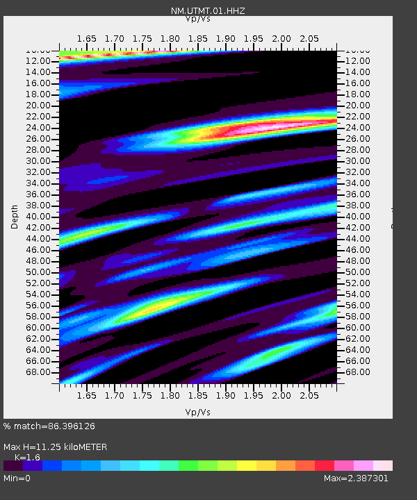
| Estimated Moho Depth: |
11.25 km |
| Estimated Crust Vp/Vs: |
1.60 |
| Assumed Crust Vp: |
6.444 km/s |
| Estimated Crust Vs: |
4.027 km/s |
| Estimated Crust Poisson's Ratio: |
0.18 |
|
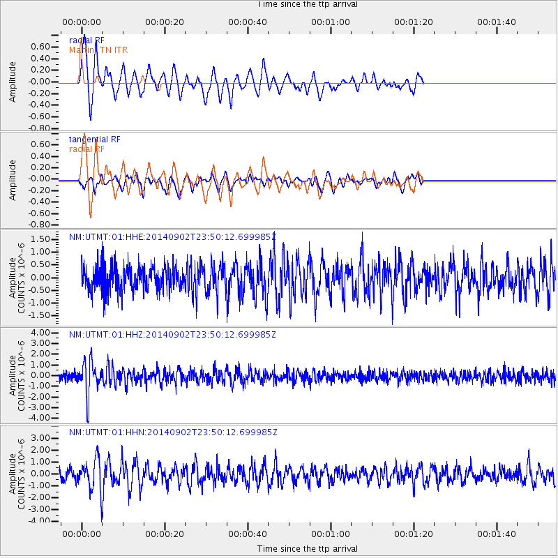
| Radial Match: |
86.396126 % |
| Radial Bump: |
400 |
| Transverse Match: |
63.119877 % |
| Transverse Bump: |
387 |
| SOD ConfigId: |
769524 |
| Insert Time: |
2014-09-17 00:29:35.960 +0000 |
| GWidth: |
2.5 |
| Max Bumps: |
400 |
| Tol: |
0.001 |
|
Signal To Noise
| Channel | StoN | STA | LTA |
| NM:UTMT:01:HHZ:20140902T23:50:12.699985Z | 4.0567646 | 1.5863362E-6 | 3.9103483E-7 |
| NM:UTMT:01:HHN:20140902T23:50:12.699985Z | 3.2618399 | 1.2697807E-6 | 3.8928354E-7 |
| NM:UTMT:01:HHE:20140902T23:50:12.699985Z | 1.160958 | 5.4433673E-7 | 4.6886854E-7 |
| Arrivals |
| Ps | 1.1 SECOND |
| PpPs | 4.3 SECOND |
| PsPs/PpSs | 5.4 SECOND |


