You are here: Home > Network List > TA - USArray Transportable Network (new EarthScope stations) Stations List
> Station J62A Henniker, NH, USA > Earthquake Result Viewer
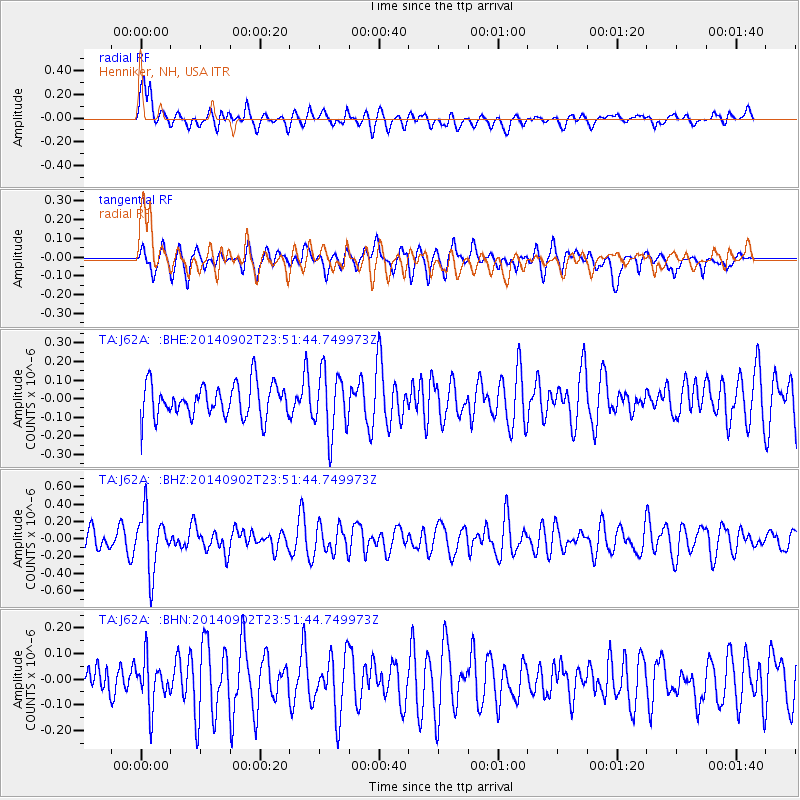
J62A Henniker, NH, USA - Earthquake Result Viewer
*The percent match for this event was below the threshold and hence no stack was calculated.
| Earthquake location: |
Central East Pacific Rise |
| Earthquake latitude/longitude: |
-11.6/-112.0 |
| Earthquake time(UTC): |
2014/09/02 (245) 23:41:31 GMT |
| Earthquake Depth: |
10 km |
| Earthquake Magnitude: |
5.5 MWP |
| Earthquake Catalog/Contributor: |
NEIC PDE/NEIC COMCAT |
|
| Network: |
TA USArray Transportable Network (new EarthScope stations) |
| Station: |
J62A Henniker, NH, USA |
| Lat/Lon: |
43.23 N/71.81 W |
| Elevation: |
266 m |
|
| Distance: |
65.7 deg |
| Az: |
31.164 deg |
| Baz: |
223.927 deg |
| Ray Param: |
$rayparam |
*The percent match for this event was below the threshold and hence was not used in the summary stack. |
|
| Radial Match: |
49.603695 % |
| Radial Bump: |
400 |
| Transverse Match: |
46.95906 % |
| Transverse Bump: |
361 |
| SOD ConfigId: |
769524 |
| Insert Time: |
2014-09-17 00:44:39.618 +0000 |
| GWidth: |
2.5 |
| Max Bumps: |
400 |
| Tol: |
0.001 |
|
Signal To Noise
| Channel | StoN | STA | LTA |
| TA:J62A: :BHZ:20140902T23:51:44.749973Z | 2.6706834 | 3.3076208E-7 | 1.2384923E-7 |
| TA:J62A: :BHN:20140902T23:51:44.749973Z | 0.75300187 | 8.950376E-8 | 1.18862594E-7 |
| TA:J62A: :BHE:20140902T23:51:44.749973Z | 1.8603897 | 1.6672132E-7 | 8.961635E-8 |
| Arrivals |
| Ps | |
| PpPs | |
| PsPs/PpSs | |


