You are here: Home > Network List > AK - Alaska Regional Network Stations List
> Station KTH Kantishna Hills > Earthquake Result Viewer
KTH Kantishna Hills - Earthquake Result Viewer
| Earthquake location: |
Nepal |
| Earthquake latitude/longitude: |
28.2/84.7 |
| Earthquake time(UTC): |
2015/04/25 (115) 06:11:25 GMT |
| Earthquake Depth: |
12 km |
| Earthquake Magnitude: |
7.5 MWB |
| Earthquake Catalog/Contributor: |
NEIC PDE/NEIC COMCAT |
|
| Network: |
AK Alaska Regional Network |
| Station: |
KTH Kantishna Hills |
| Lat/Lon: |
63.55 N/150.92 W |
| Elevation: |
1172 m |
|
| Distance: |
78.7 deg |
| Az: |
22.15 deg |
| Baz: |
311.976 deg |
| Ray Param: |
0.04949242 |
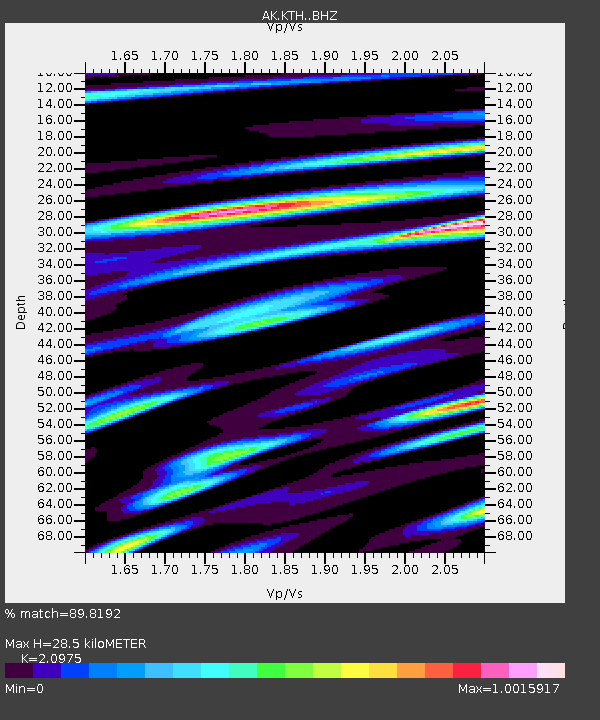
| Estimated Moho Depth: |
28.5 km |
| Estimated Crust Vp/Vs: |
2.10 |
| Assumed Crust Vp: |
6.438 km/s |
| Estimated Crust Vs: |
3.069 km/s |
| Estimated Crust Poisson's Ratio: |
0.35 |
|
| Radial Match: |
89.8192 % |
| Radial Bump: |
400 |
| Transverse Match: |
85.96801 % |
| Transverse Bump: |
400 |
| SOD ConfigId: |
7422571 |
| Insert Time: |
2019-04-18 08:35:06.427 +0000 |
| GWidth: |
2.5 |
| Max Bumps: |
400 |
| Tol: |
0.001 |
|

Signal To Noise
| Channel | StoN | STA | LTA |
| AK:KTH: :BHZ:20150425T06:22:56.947991Z | 6.9009557 | 2.0043487E-6 | 2.9044512E-7 |
| AK:KTH: :BHN:20150425T06:22:56.947991Z | 2.5218592 | 5.600431E-7 | 2.2207547E-7 |
| AK:KTH: :BHE:20150425T06:22:56.947991Z | 1.9088862 | 4.7613247E-7 | 2.4942946E-7 |
| Arrivals |
| Ps | 5.0 SECOND |
| PpPs | 13 SECOND |
| PsPs/PpSs | 18 SECOND |


