You are here: Home > Network List > AK - Alaska Regional Network Stations List
> Station MDM Murphy Dome > Earthquake Result Viewer
MDM Murphy Dome - Earthquake Result Viewer
| Earthquake location: |
Nepal |
| Earthquake latitude/longitude: |
28.2/84.7 |
| Earthquake time(UTC): |
2015/04/25 (115) 06:11:25 GMT |
| Earthquake Depth: |
12 km |
| Earthquake Magnitude: |
7.5 MWB |
| Earthquake Catalog/Contributor: |
NEIC PDE/NEIC COMCAT |
|
| Network: |
AK Alaska Regional Network |
| Station: |
MDM Murphy Dome |
| Lat/Lon: |
64.96 N/148.23 W |
| Elevation: |
634 m |
|
| Distance: |
78.5 deg |
| Az: |
20.279 deg |
| Baz: |
314.028 deg |
| Ray Param: |
0.049562104 |
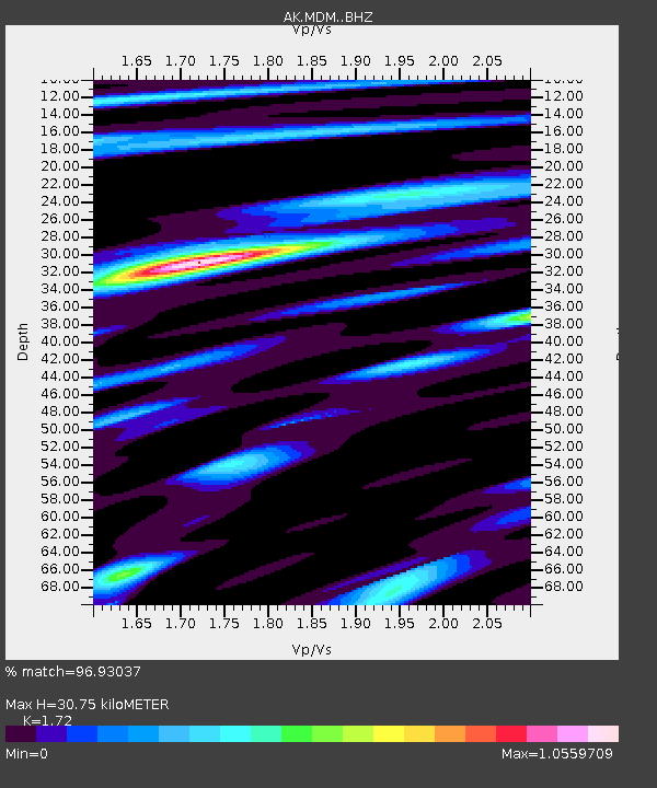
| Estimated Moho Depth: |
30.75 km |
| Estimated Crust Vp/Vs: |
1.72 |
| Assumed Crust Vp: |
6.566 km/s |
| Estimated Crust Vs: |
3.818 km/s |
| Estimated Crust Poisson's Ratio: |
0.24 |
|
| Radial Match: |
96.93037 % |
| Radial Bump: |
400 |
| Transverse Match: |
87.7155 % |
| Transverse Bump: |
400 |
| SOD ConfigId: |
7422571 |
| Insert Time: |
2019-04-18 08:35:08.008 +0000 |
| GWidth: |
2.5 |
| Max Bumps: |
400 |
| Tol: |
0.001 |
|
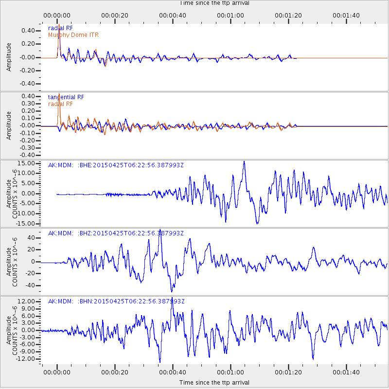
Signal To Noise
| Channel | StoN | STA | LTA |
| AK:MDM: :BHZ:20150425T06:22:56.387993Z | 8.67976 | 2.6861915E-6 | 3.094776E-7 |
| AK:MDM: :BHN:20150425T06:22:56.387993Z | 2.5014565 | 5.419E-7 | 2.166338E-7 |
| AK:MDM: :BHE:20150425T06:22:56.387993Z | 3.940214 | 6.229086E-7 | 1.5809005E-7 |
| Arrivals |
| Ps | 3.5 SECOND |
| PpPs | 12 SECOND |
| PsPs/PpSs | 16 SECOND |


