You are here: Home > Network List > TA - USArray Transportable Network (new EarthScope stations) Stations List
> Station O03E Paynes Creek, CA, USA > Earthquake Result Viewer
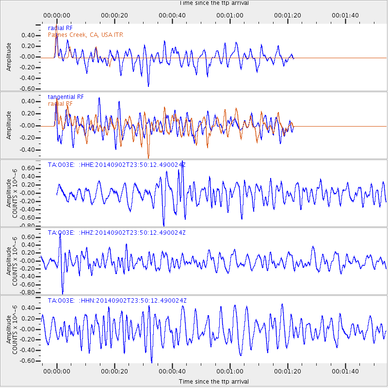
O03E Paynes Creek, CA, USA - Earthquake Result Viewer
*The percent match for this event was below the threshold and hence no stack was calculated.
| Earthquake location: |
Central East Pacific Rise |
| Earthquake latitude/longitude: |
-11.6/-112.0 |
| Earthquake time(UTC): |
2014/09/02 (245) 23:41:31 GMT |
| Earthquake Depth: |
10 km |
| Earthquake Magnitude: |
5.5 MWP |
| Earthquake Catalog/Contributor: |
NEIC PDE/NEIC COMCAT |
|
| Network: |
TA USArray Transportable Network (new EarthScope stations) |
| Station: |
O03E Paynes Creek, CA, USA |
| Lat/Lon: |
40.29 N/121.80 W |
| Elevation: |
967 m |
|
| Distance: |
52.4 deg |
| Az: |
350.551 deg |
| Baz: |
167.859 deg |
| Ray Param: |
$rayparam |
*The percent match for this event was below the threshold and hence was not used in the summary stack. |
|
| Radial Match: |
56.519833 % |
| Radial Bump: |
400 |
| Transverse Match: |
56.036617 % |
| Transverse Bump: |
400 |
| SOD ConfigId: |
769524 |
| Insert Time: |
2014-09-17 00:47:19.976 +0000 |
| GWidth: |
2.5 |
| Max Bumps: |
400 |
| Tol: |
0.001 |
|
Signal To Noise
| Channel | StoN | STA | LTA |
| TA:O03E: :HHZ:20140902T23:50:12.490024Z | 3.4232528 | 3.4285367E-7 | 1.0015435E-7 |
| TA:O03E: :HHN:20140902T23:50:12.490024Z | 1.1253568 | 1.2417884E-7 | 1.1034619E-7 |
| TA:O03E: :HHE:20140902T23:50:12.490024Z | 1.0549872 | 1.4358001E-7 | 1.3609645E-7 |
| Arrivals |
| Ps | |
| PpPs | |
| PsPs/PpSs | |


