You are here: Home > Network List > TA - USArray Transportable Network (new EarthScope stations) Stations List
> Station O51A Pataskala, OH, USA > Earthquake Result Viewer
O51A Pataskala, OH, USA - Earthquake Result Viewer
| Earthquake location: |
Central East Pacific Rise |
| Earthquake latitude/longitude: |
-11.6/-112.0 |
| Earthquake time(UTC): |
2014/09/02 (245) 23:41:31 GMT |
| Earthquake Depth: |
10 km |
| Earthquake Magnitude: |
5.5 MWP |
| Earthquake Catalog/Contributor: |
NEIC PDE/NEIC COMCAT |
|
| Network: |
TA USArray Transportable Network (new EarthScope stations) |
| Station: |
O51A Pataskala, OH, USA |
| Lat/Lon: |
40.15 N/82.61 W |
| Elevation: |
380 m |
|
| Distance: |
58.2 deg |
| Az: |
26.269 deg |
| Baz: |
214.457 deg |
| Ray Param: |
0.06296825 |
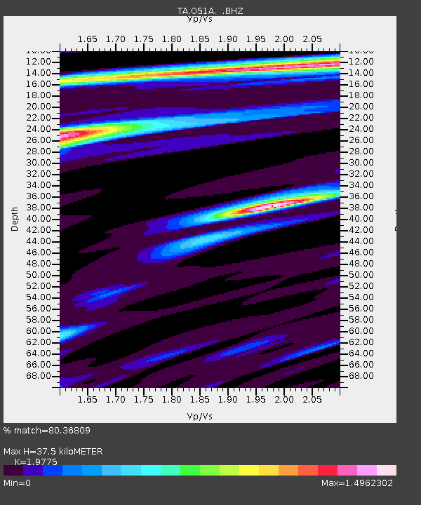
| Estimated Moho Depth: |
37.5 km |
| Estimated Crust Vp/Vs: |
1.98 |
| Assumed Crust Vp: |
6.498 km/s |
| Estimated Crust Vs: |
3.286 km/s |
| Estimated Crust Poisson's Ratio: |
0.33 |
|
| Radial Match: |
80.36809 % |
| Radial Bump: |
385 |
| Transverse Match: |
55.785862 % |
| Transverse Bump: |
400 |
| SOD ConfigId: |
769524 |
| Insert Time: |
2014-09-17 00:47:23.257 +0000 |
| GWidth: |
2.5 |
| Max Bumps: |
400 |
| Tol: |
0.001 |
|

Signal To Noise
| Channel | StoN | STA | LTA |
| TA:O51A: :BHZ:20140902T23:50:54.524998Z | 7.5814133 | 4.63381E-7 | 6.1120666E-8 |
| TA:O51A: :BHN:20140902T23:50:54.524998Z | 2.5802772 | 2.327752E-7 | 9.021325E-8 |
| TA:O51A: :BHE:20140902T23:50:54.524998Z | 2.1568222 | 1.7783017E-7 | 8.2450086E-8 |
| Arrivals |
| Ps | 5.9 SECOND |
| PpPs | 16 SECOND |
| PsPs/PpSs | 22 SECOND |


