You are here: Home > Network List > CI - Caltech Regional Seismic Network Stations List
> Station ISA Isabella, Lake Isabella, CA, USA > Earthquake Result Viewer
ISA Isabella, Lake Isabella, CA, USA - Earthquake Result Viewer
| Earthquake location: |
North Of Honduras |
| Earthquake latitude/longitude: |
16.7/-86.2 |
| Earthquake time(UTC): |
2009/05/28 (148) 08:24:45 GMT |
| Earthquake Depth: |
10 km |
| Earthquake Magnitude: |
6.7 MB, 7.2 MS, 7.3 MW, 7.3 MW |
| Earthquake Catalog/Contributor: |
WHDF/NEIC |
|
| Network: |
CI Caltech Regional Seismic Network |
| Station: |
ISA Isabella, Lake Isabella, CA, USA |
| Lat/Lon: |
35.66 N/118.47 W |
| Elevation: |
873 m |
|
| Distance: |
34.3 deg |
| Az: |
309.591 deg |
| Baz: |
114.928 deg |
| Ray Param: |
0.07780413 |
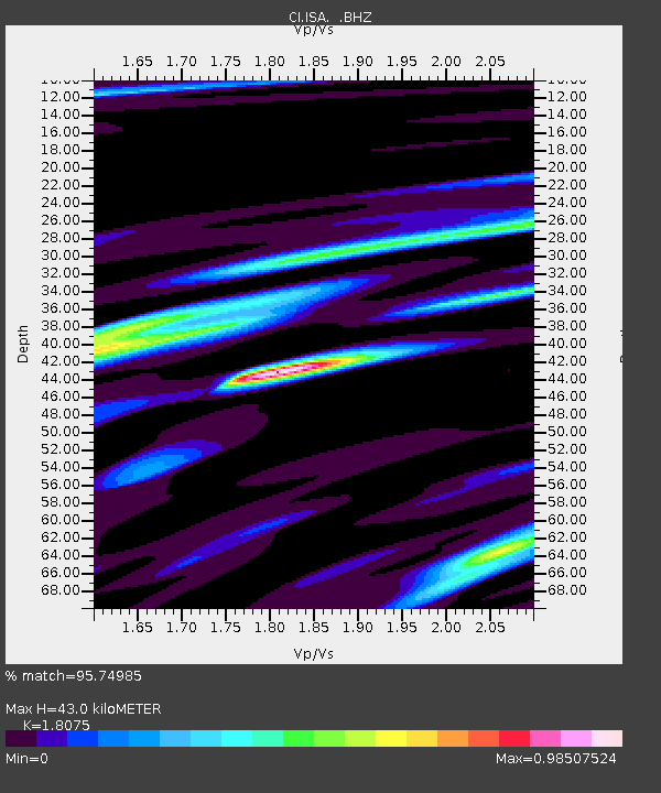
| Estimated Moho Depth: |
43.0 km |
| Estimated Crust Vp/Vs: |
1.81 |
| Assumed Crust Vp: |
6.1 km/s |
| Estimated Crust Vs: |
3.375 km/s |
| Estimated Crust Poisson's Ratio: |
0.28 |
|
| Radial Match: |
95.74985 % |
| Radial Bump: |
365 |
| Transverse Match: |
85.39933 % |
| Transverse Bump: |
400 |
| SOD ConfigId: |
2648 |
| Insert Time: |
2010-02-25 21:15:26.512 +0000 |
| GWidth: |
2.5 |
| Max Bumps: |
400 |
| Tol: |
0.001 |
|

Signal To Noise
| Channel | StoN | STA | LTA |
| CI:ISA: :BHZ:20090528T08:31:00.86299Z | 32.393993 | 4.538419E-6 | 1.4010064E-7 |
| CI:ISA: :BHN:20090528T08:31:00.86299Z | 21.400858 | 1.5353233E-6 | 7.1741205E-8 |
| CI:ISA: :BHE:20090528T08:31:00.86299Z | 32.950844 | 1.3374438E-6 | 4.058906E-8 |
| Arrivals |
| Ps | 6.1 SECOND |
| PpPs | 18 SECOND |
| PsPs/PpSs | 25 SECOND |


