You are here: Home > Network List > TA - USArray Transportable Network (new EarthScope stations) Stations List
> Station P54A Burton, WV, USA > Earthquake Result Viewer
P54A Burton, WV, USA - Earthquake Result Viewer
| Earthquake location: |
Central East Pacific Rise |
| Earthquake latitude/longitude: |
-11.6/-112.0 |
| Earthquake time(UTC): |
2014/09/02 (245) 23:41:31 GMT |
| Earthquake Depth: |
10 km |
| Earthquake Magnitude: |
5.5 MWP |
| Earthquake Catalog/Contributor: |
NEIC PDE/NEIC COMCAT |
|
| Network: |
TA USArray Transportable Network (new EarthScope stations) |
| Station: |
P54A Burton, WV, USA |
| Lat/Lon: |
39.61 N/80.48 W |
| Elevation: |
473 m |
|
| Distance: |
58.8 deg |
| Az: |
28.195 deg |
| Baz: |
216.821 deg |
| Ray Param: |
0.06263133 |
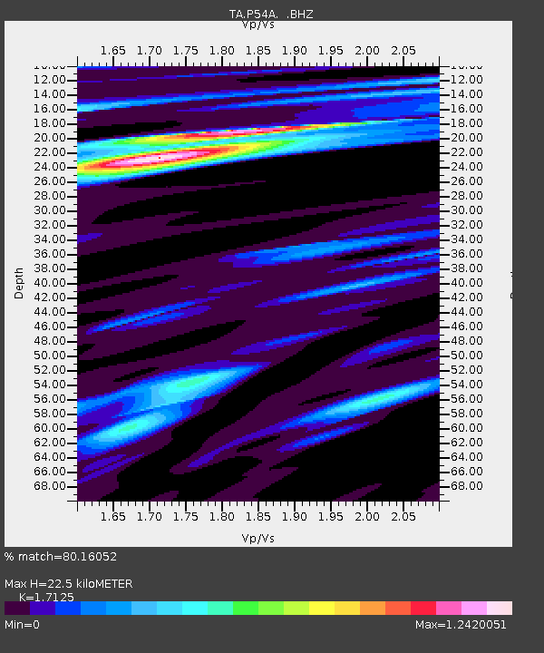
| Estimated Moho Depth: |
22.5 km |
| Estimated Crust Vp/Vs: |
1.71 |
| Assumed Crust Vp: |
6.207 km/s |
| Estimated Crust Vs: |
3.625 km/s |
| Estimated Crust Poisson's Ratio: |
0.24 |
|
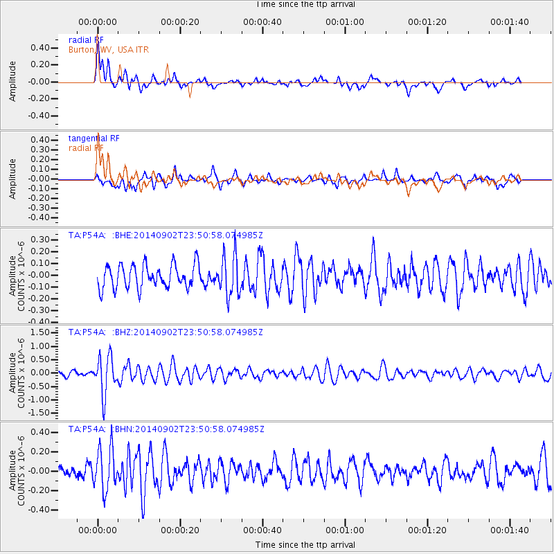
| Radial Match: |
80.16052 % |
| Radial Bump: |
400 |
| Transverse Match: |
60.4613 % |
| Transverse Bump: |
400 |
| SOD ConfigId: |
769524 |
| Insert Time: |
2014-09-17 00:47:59.343 +0000 |
| GWidth: |
2.5 |
| Max Bumps: |
400 |
| Tol: |
0.001 |
|
Signal To Noise
| Channel | StoN | STA | LTA |
| TA:P54A: :BHZ:20140902T23:50:58.074985Z | 9.15072 | 7.2407596E-7 | 7.9127766E-8 |
| TA:P54A: :BHN:20140902T23:50:58.074985Z | 2.876665 | 2.2374583E-7 | 7.777958E-8 |
| TA:P54A: :BHE:20140902T23:50:58.074985Z | 1.7910993 | 1.7486043E-7 | 9.762744E-8 |
| Arrivals |
| Ps | 2.7 SECOND |
| PpPs | 9.4 SECOND |
| PsPs/PpSs | 12 SECOND |


