You are here: Home > Network List > AK - Alaska Regional Network Stations List
> Station SSP Sunshine Point, AK, USA > Earthquake Result Viewer
SSP Sunshine Point, AK, USA - Earthquake Result Viewer
| Earthquake location: |
Nepal |
| Earthquake latitude/longitude: |
28.2/84.7 |
| Earthquake time(UTC): |
2015/04/25 (115) 06:11:25 GMT |
| Earthquake Depth: |
12 km |
| Earthquake Magnitude: |
7.5 MWB |
| Earthquake Catalog/Contributor: |
NEIC PDE/NEIC COMCAT |
|
| Network: |
AK Alaska Regional Network |
| Station: |
SSP Sunshine Point, AK, USA |
| Lat/Lon: |
60.18 N/142.84 W |
| Elevation: |
474 m |
|
| Distance: |
83.7 deg |
| Az: |
21.782 deg |
| Baz: |
319.041 deg |
| Ray Param: |
0.045965567 |
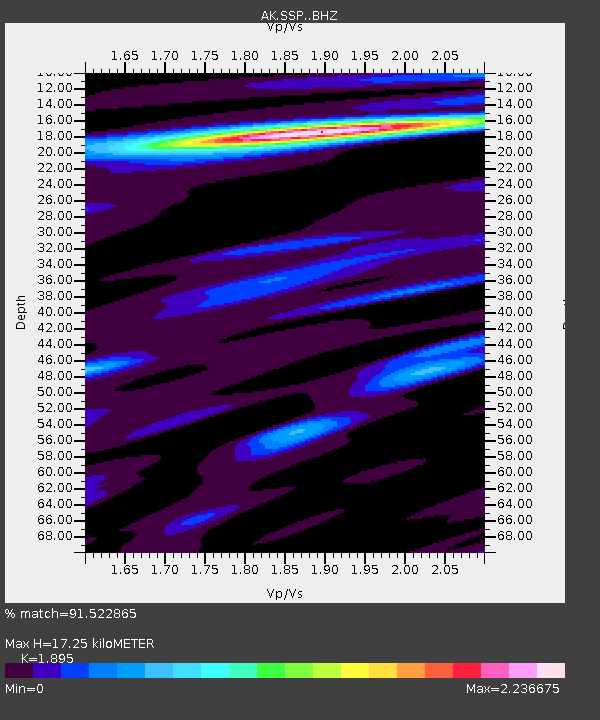
| Estimated Moho Depth: |
17.25 km |
| Estimated Crust Vp/Vs: |
1.89 |
| Assumed Crust Vp: |
6.566 km/s |
| Estimated Crust Vs: |
3.465 km/s |
| Estimated Crust Poisson's Ratio: |
0.31 |
|
| Radial Match: |
91.522865 % |
| Radial Bump: |
400 |
| Transverse Match: |
91.498665 % |
| Transverse Bump: |
400 |
| SOD ConfigId: |
7422571 |
| Insert Time: |
2019-04-18 08:35:24.425 +0000 |
| GWidth: |
2.5 |
| Max Bumps: |
400 |
| Tol: |
0.001 |
|

Signal To Noise
| Channel | StoN | STA | LTA |
| AK:SSP: :BHZ:20150425T06:23:23.908013Z | 2.093068 | 6.3379906E-7 | 3.0280864E-7 |
| AK:SSP: :BHN:20150425T06:23:23.908013Z | 1.3020546 | 4.5800977E-7 | 3.5175927E-7 |
| AK:SSP: :BHE:20150425T06:23:23.908013Z | 1.1402527 | 2.3158962E-7 | 2.0310377E-7 |
| Arrivals |
| Ps | 2.4 SECOND |
| PpPs | 7.4 SECOND |
| PsPs/PpSs | 9.8 SECOND |


