You are here: Home > Network List > TA - USArray Transportable Network (new EarthScope stations) Stations List
> Station U55A TA2, Sparta, NC, USA > Earthquake Result Viewer
U55A TA2, Sparta, NC, USA - Earthquake Result Viewer
| Earthquake location: |
Central East Pacific Rise |
| Earthquake latitude/longitude: |
-11.6/-112.0 |
| Earthquake time(UTC): |
2014/09/02 (245) 23:41:31 GMT |
| Earthquake Depth: |
10 km |
| Earthquake Magnitude: |
5.5 MWP |
| Earthquake Catalog/Contributor: |
NEIC PDE/NEIC COMCAT |
|
| Network: |
TA USArray Transportable Network (new EarthScope stations) |
| Station: |
U55A TA2, Sparta, NC, USA |
| Lat/Lon: |
36.50 N/81.05 W |
| Elevation: |
863 m |
|
| Distance: |
56.0 deg |
| Az: |
29.994 deg |
| Baz: |
217.442 deg |
| Ray Param: |
0.0644134 |
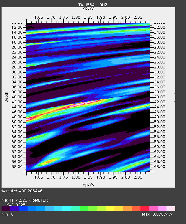
| Estimated Moho Depth: |
42.25 km |
| Estimated Crust Vp/Vs: |
1.83 |
| Assumed Crust Vp: |
6.159 km/s |
| Estimated Crust Vs: |
3.361 km/s |
| Estimated Crust Poisson's Ratio: |
0.29 |
|
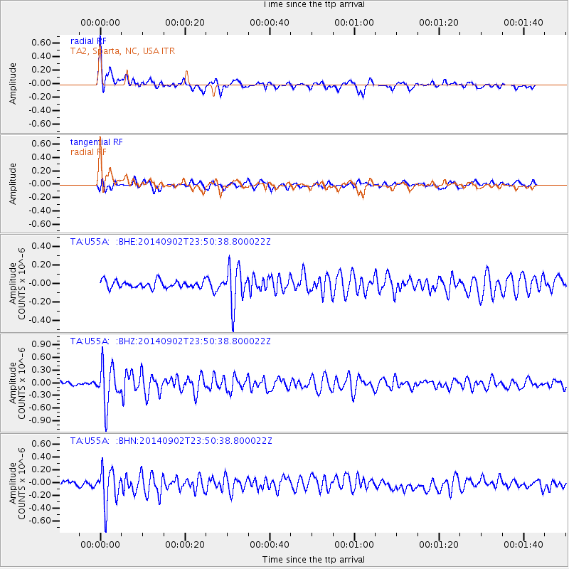
| Radial Match: |
80.285446 % |
| Radial Bump: |
400 |
| Transverse Match: |
56.47464 % |
| Transverse Bump: |
400 |
| SOD ConfigId: |
769524 |
| Insert Time: |
2014-09-17 00:50:19.844 +0000 |
| GWidth: |
2.5 |
| Max Bumps: |
400 |
| Tol: |
0.001 |
|
Signal To Noise
| Channel | StoN | STA | LTA |
| TA:U55A: :BHZ:20140902T23:50:38.800022Z | 7.591253 | 4.7784886E-7 | 6.29473E-8 |
| TA:U55A: :BHN:20140902T23:50:38.800022Z | 5.5793214 | 2.824443E-7 | 5.0623413E-8 |
| TA:U55A: :BHE:20140902T23:50:38.800022Z | 5.3880363 | 2.0697392E-7 | 3.841361E-8 |
| Arrivals |
| Ps | 6.0 SECOND |
| PpPs | 19 SECOND |
| PsPs/PpSs | 25 SECOND |


