You are here: Home > Network List > AU - Australian Seismological Centre Stations List
> Station MUN Mundaring, Western Australia > Earthquake Result Viewer
MUN Mundaring, Western Australia - Earthquake Result Viewer
| Earthquake location: |
Nepal |
| Earthquake latitude/longitude: |
28.2/84.7 |
| Earthquake time(UTC): |
2015/04/25 (115) 06:11:25 GMT |
| Earthquake Depth: |
12 km |
| Earthquake Magnitude: |
7.5 MWB |
| Earthquake Catalog/Contributor: |
NEIC PDE/NEIC COMCAT |
|
| Network: |
AU Australian Seismological Centre |
| Station: |
MUN Mundaring, Western Australia |
| Lat/Lon: |
31.98 S/116.21 E |
| Elevation: |
253 m |
|
| Distance: |
66.9 deg |
| Az: |
151.149 deg |
| Baz: |
329.914 deg |
| Ray Param: |
0.057307646 |
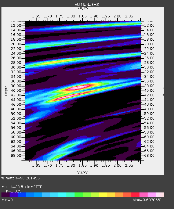
| Estimated Moho Depth: |
38.5 km |
| Estimated Crust Vp/Vs: |
1.83 |
| Assumed Crust Vp: |
6.419 km/s |
| Estimated Crust Vs: |
3.517 km/s |
| Estimated Crust Poisson's Ratio: |
0.29 |
|
| Radial Match: |
98.281456 % |
| Radial Bump: |
301 |
| Transverse Match: |
92.30082 % |
| Transverse Bump: |
400 |
| SOD ConfigId: |
7422571 |
| Insert Time: |
2019-04-18 08:35:54.124 +0000 |
| GWidth: |
2.5 |
| Max Bumps: |
400 |
| Tol: |
0.001 |
|

Signal To Noise
| Channel | StoN | STA | LTA |
| AU:MUN: :BHZ:20150425T06:21:46.994011Z | 4.8614607 | 2.0814834E-6 | 4.281601E-7 |
| AU:MUN: :BHN:20150425T06:21:46.994011Z | 3.4846356 | 1.1070148E-6 | 3.176845E-7 |
| AU:MUN: :BHE:20150425T06:21:46.994011Z | 1.8463736 | 6.714829E-7 | 3.6367663E-7 |
| Arrivals |
| Ps | 5.1 SECOND |
| PpPs | 16 SECOND |
| PsPs/PpSs | 21 SECOND |


