You are here: Home > Network List > AV - Alaska Volcano Observatory Stations List
> Station MAPS Pakushin Southeast, Makushin Volcano, Alaska > Earthquake Result Viewer
MAPS Pakushin Southeast, Makushin Volcano, Alaska - Earthquake Result Viewer
| Earthquake location: |
Nepal |
| Earthquake latitude/longitude: |
28.2/84.7 |
| Earthquake time(UTC): |
2015/04/25 (115) 06:11:25 GMT |
| Earthquake Depth: |
12 km |
| Earthquake Magnitude: |
7.5 MWB |
| Earthquake Catalog/Contributor: |
NEIC PDE/NEIC COMCAT |
|
| Network: |
AV Alaska Volcano Observatory |
| Station: |
MAPS Pakushin Southeast, Makushin Volcano, Alaska |
| Lat/Lon: |
53.81 N/166.94 W |
| Elevation: |
333 m |
|
| Distance: |
77.7 deg |
| Az: |
35.186 deg |
| Baz: |
300.926 deg |
| Ray Param: |
0.05015351 |
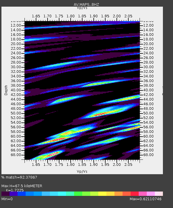
| Estimated Moho Depth: |
67.5 km |
| Estimated Crust Vp/Vs: |
1.72 |
| Assumed Crust Vp: |
3.943 km/s |
| Estimated Crust Vs: |
2.289 km/s |
| Estimated Crust Poisson's Ratio: |
0.25 |
|
| Radial Match: |
92.37867 % |
| Radial Bump: |
400 |
| Transverse Match: |
87.70121 % |
| Transverse Bump: |
400 |
| SOD ConfigId: |
7422571 |
| Insert Time: |
2019-04-18 08:36:06.585 +0000 |
| GWidth: |
2.5 |
| Max Bumps: |
400 |
| Tol: |
0.001 |
|
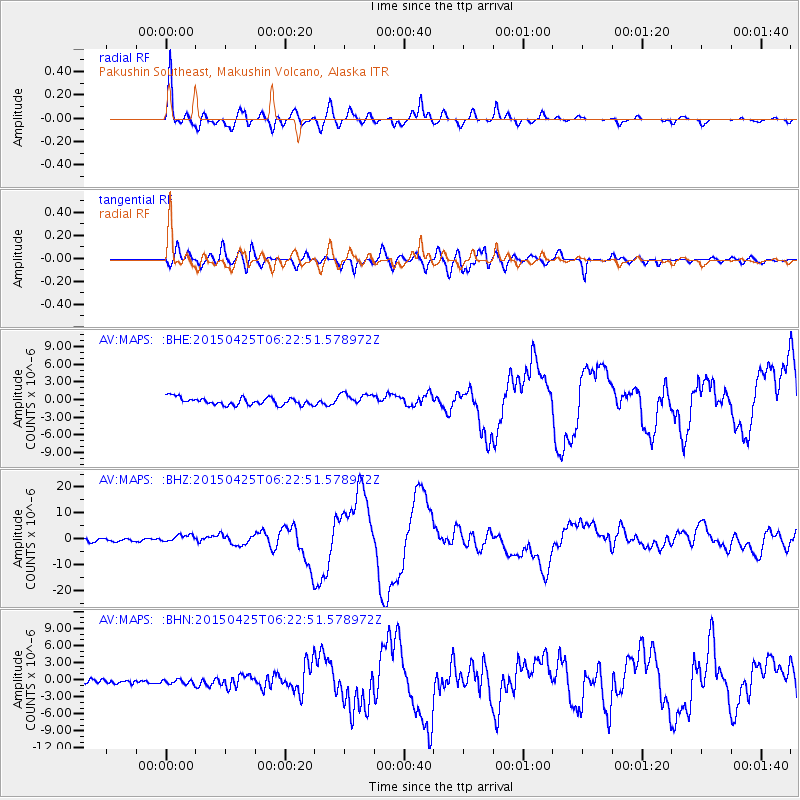
Signal To Noise
| Channel | StoN | STA | LTA |
| AV:MAPS: :BHZ:20150425T06:22:51.578972Z | 2.2338493 | 1.4723719E-6 | 6.591187E-7 |
| AV:MAPS: :BHN:20150425T06:22:51.578972Z | 0.7971905 | 4.2411483E-7 | 5.320119E-7 |
| AV:MAPS: :BHE:20150425T06:22:51.578972Z | 1.551122 | 9.765157E-7 | 6.2955445E-7 |
| Arrivals |
| Ps | 13 SECOND |
| PpPs | 46 SECOND |
| PsPs/PpSs | 59 SECOND |


