You are here: Home > Network List > TA - USArray Transportable Network (new EarthScope stations) Stations List
> Station X58A Rowland, NC, USA > Earthquake Result Viewer
X58A Rowland, NC, USA - Earthquake Result Viewer
| Earthquake location: |
Central East Pacific Rise |
| Earthquake latitude/longitude: |
-11.6/-112.0 |
| Earthquake time(UTC): |
2014/09/02 (245) 23:41:31 GMT |
| Earthquake Depth: |
10 km |
| Earthquake Magnitude: |
5.5 MWP |
| Earthquake Catalog/Contributor: |
NEIC PDE/NEIC COMCAT |
|
| Network: |
TA USArray Transportable Network (new EarthScope stations) |
| Station: |
X58A Rowland, NC, USA |
| Lat/Lon: |
34.55 N/79.34 W |
| Elevation: |
45 m |
|
| Distance: |
55.4 deg |
| Az: |
32.781 deg |
| Baz: |
220.002 deg |
| Ray Param: |
0.06483304 |
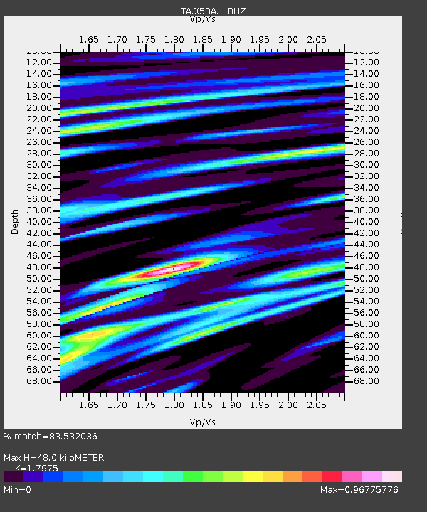
| Estimated Moho Depth: |
48.0 km |
| Estimated Crust Vp/Vs: |
1.80 |
| Assumed Crust Vp: |
6.565 km/s |
| Estimated Crust Vs: |
3.652 km/s |
| Estimated Crust Poisson's Ratio: |
0.28 |
|
| Radial Match: |
83.532036 % |
| Radial Bump: |
400 |
| Transverse Match: |
58.71943 % |
| Transverse Bump: |
400 |
| SOD ConfigId: |
769524 |
| Insert Time: |
2014-09-17 00:51:34.565 +0000 |
| GWidth: |
2.5 |
| Max Bumps: |
400 |
| Tol: |
0.001 |
|
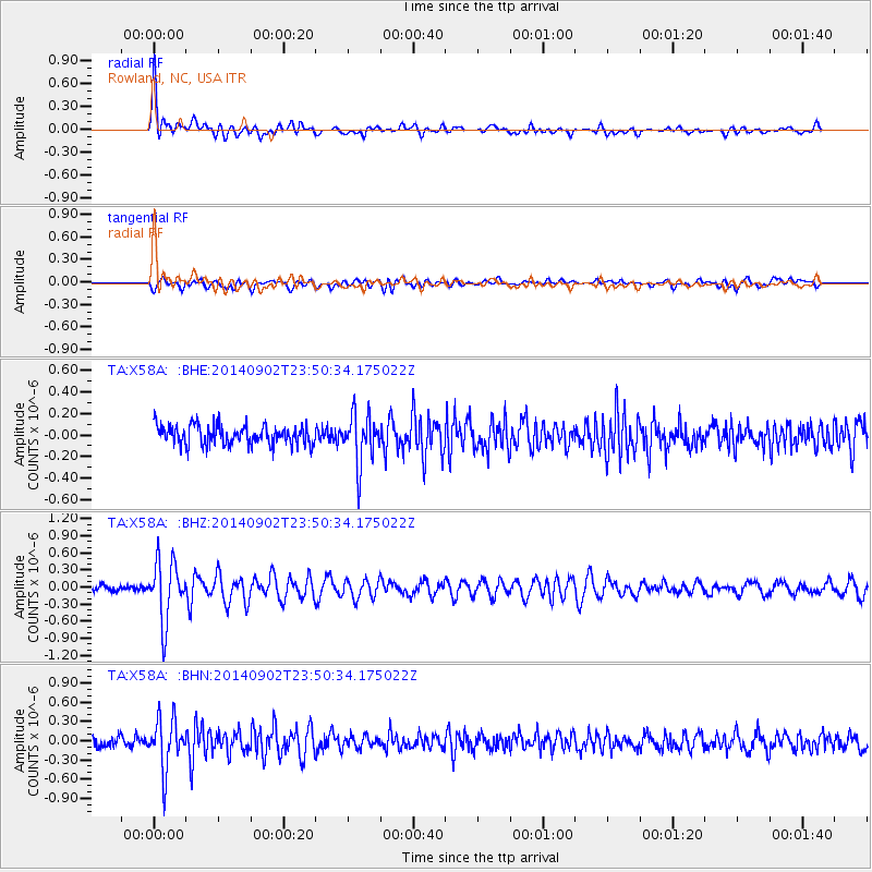
Signal To Noise
| Channel | StoN | STA | LTA |
| TA:X58A: :BHZ:20140902T23:50:34.175022Z | 9.303048 | 5.2235947E-7 | 5.614928E-8 |
| TA:X58A: :BHN:20140902T23:50:34.175022Z | 4.5403314 | 3.8871735E-7 | 8.561431E-8 |
| TA:X58A: :BHE:20140902T23:50:34.175022Z | 2.5216146 | 2.3218823E-7 | 9.207919E-8 |
| Arrivals |
| Ps | 6.2 SECOND |
| PpPs | 19 SECOND |
| PsPs/PpSs | 26 SECOND |


